Golacir geodata
Golacir (West Java) is a seat of a fourth-order administrative division; located in Indonesia in Asia/Jakarta (GMT+7) time zone. In our database, there are 407 cities with bigger population. Compared to other cities in Indonesia, 50.2% of cities are located further ↑North; 78.3% of cities are located further →East and 80.7% of cities have lower elevation than Golacir. Note1


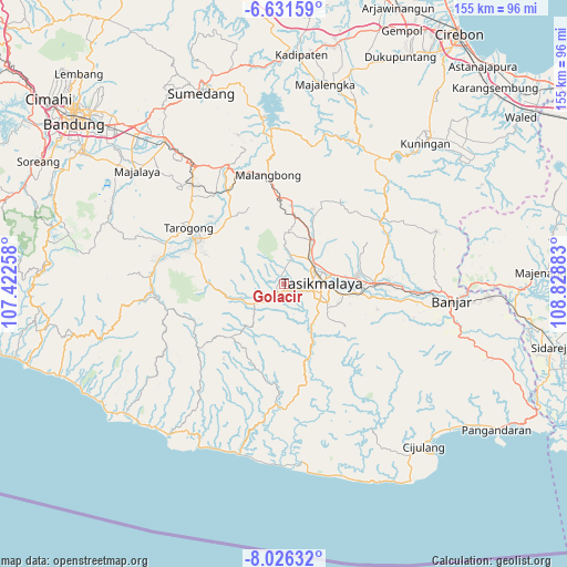
Golacir GPS coordinates[2]
7° 19' 46.2" South, 108° 7' 32.52" East
| Map corner | latitude | longitude |
|---|---|---|
| Upper-left | -6.63159°, | 107.42258° |
| Center: | -7.3295°, | 108.1257° |
| Lower-right: | -8.02632°, | 108.82883° |
| Map W x H: | 155.1×155.1 km | = 96.4×96.4mi |
| max Lat: | 5.88969° ⇑50.2% North |
| Golacir: | -7.3295° |
| min Lat: | ⇓49.8% South -10.934° |
| min Long | Golacir | max Long |
| 95.1345° | 108.1257° | 140.9419° |
| W 21.7%⇐ | ⇒78.3% E |
Elevation
Elevation of Golacir is 443 m = 1453 ft, and this is 213.3 m = 700 ft above average elevation for this country.
| Max E: |
3185 m = 10449 ft | 19.3% |
| Golacir | 443 m 1453 ft | |
| Avg. | 229.7 m = 754 ft | |
Min E: |
-1 m = -3 ft | 80.7% |
See also: Indonesia elevation on elevation.city.
Geographical zone
Golacir is located in South Torrid zone (between Equator and Tropic of Capricorn). Distance of Equator is 815 km =506.4 mi to North.| Distance of | km | miles | from Golacir |
|---|---|---|---|
| Equator | 815 | 506.4 | to North |
| Tropic Capricorn | 1791 | 1112.9 | to South |
| Antarctic Circle | 6586.2 | 4092.5 | to South |
| South Pole | 9192.1 | 5711.7 | to South |


Nearby cities:
15 places around Golacir: (largest is in red/bold)
• Arjasari
2.8 km =1.7 mi,  253°
253°
• Banjarsari
2.7 km =1.7 mi,  54°
54°
• Ciawang
1.6 km =1 mi,  300°
300°
• Cibenda
2.3 km =1.4 mi,  349°
349°
• Cidamar
2.3 km =1.4 mi,  141°
141°
• Cimanglid
2.2 km =1.4 mi,  218°
218°
• Cisaro
2.7 km =1.7 mi,  189°
189°
• Gunungbatara
2 km =1.2 mi,  55°
55°
• Gunungkawung
2.8 km =1.7 mi,  111°
111°
• Nanggorak
3.2 km =2 mi, 297°
• Panayagan
3.3 km =2.1 mi,  211°
211°
• Sayuran
2.3 km =1.4 mi,  244°
244°
• Selawangi
3.3 km =2.1 mi,  260°
260°
• Singaparna
2.9 km =1.8 mi, 213°
• Sukamulya
3.4 km =2.1 mi, 191°
Sources, notices
• [Note1] Compared only with cities in Indonesia existing in our database
• [Src1] Map data: © OpenStreetMap contributors (CC-BY-SA)
• [Src2] Other city data from geonames.org with taken over terms of usage.
• [Src3] Geographical zone / Annual Mean Temperature by Robert A. Rohde @ Wikipedia
