Kedungbulu geodata
Kedungbulu (Central Java) is a seat of a fourth-order administrative division; located in Indonesia in Asia/Jakarta (GMT+7) time zone. In our database, there are 407 cities with bigger population. Compared to other cities in Indonesia, 56.9% of cities are located further ↑North; 67.9% of cities are located further →East and 86.4% of cities have higher elevation than Kedungbulu. Note1


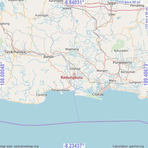
Kedungbulu GPS coordinates[2]
7° 32' 16.44" South, 108° 47' 0.96" East
| Map corner | latitude | longitude |
|---|---|---|
| Upper-left | -6.84031°, | 108.08048° |
| Center: | -7.5379°, | 108.7836° |
| Lower-right: | -8.23437°, | 109.48673° |
| Map W x H: | 155×155 km | = 96.3×96.3mi |
| max Lat: | 5.88969° ⇑56.9% North |
| Kedungbulu: | -7.5379° |
| min Lat: | ⇓43.1% South -10.934° |
| min Long | Kedungbulu | max Long |
| 95.1345° | 108.7836° | 140.9419° |
| W 32.1%⇐ | ⇒67.9% E |
Elevation
Elevation of Kedungbulu is 13 m = 43 ft, and this is 216.7 m = 711 ft below average elevation for this country.
| Max E: |
3185 m = 10449 ft | 86.4% |
| Avg. | 229.7 m = 754 ft | |
| Kedungbulu | 13 m = 43 ft | |
Min E: |
-1 m = -3 ft | 13.6% |
See also: Indonesia elevation on elevation.city.
Geographical zone
Kedungbulu is located in South Torrid zone (between Equator and Tropic of Capricorn). Distance of Equator is 838.1 km =520.8 mi to North.| Distance of | km | miles | from Kedungbulu |
|---|---|---|---|
| Equator | 838.1 | 520.8 | to North |
| Tropic Capricorn | 1767.8 | 1098.5 | to South |
| Antarctic Circle | 6563 | 4078.1 | to South |
| South Pole | 9168.9 | 5697.3 | to South |


Nearby cities:
15 places around Kedungbulu: (largest is in red/bold)
• Ciklapa
4.1 km =2.5 mi,  40°
40°
• Cinyawang
4.5 km =2.8 mi,  205°
205°
• Cipari
1.9 km =1.2 mi,  87°
87°
• Cipariuk
4.5 km =2.8 mi,  337°
337°
• Dukuhtengah
3 km =1.9 mi, 39°
• Kalenaren
4.7 km =2.9 mi,  177°
177°
• Kalenpring
5.8 km =3.6 mi, 205°
• Kedungbakung
3.8 km =2.4 mi, 342°
• Kedungreja
3.7 km =2.3 mi,  353°
353°
• Mulyosari
3.4 km =2.1 mi,  4°
4°
• Pondokwungu
2.4 km =1.5 mi,  144°
144°
• Sentul
5.6 km =3.5 mi,  245°
245°
• Sidaurip
3.7 km =2.3 mi,  263°
263°
• Tambaksari
5.4 km =3.4 mi,  318°
318°
• Wanadadi
4.2 km =2.6 mi,  82°
82°
Sources, notices
• [Note1] Compared only with cities in Indonesia existing in our database
• [Src1] Map data: © OpenStreetMap contributors (CC-BY-SA)
• [Src2] Other city data from geonames.org with taken over terms of usage.
• [Src3] Geographical zone / Annual Mean Temperature by Robert A. Rohde @ Wikipedia
