Ruteng geodata
Ruteng (East Nusa Tenggara) is a seat of a second-order administrative division; located in Indonesia in Asia/Makassar (GMT+8) time zone. With population of 34,569 people, there are 291 cities with bigger population in this country. Compared to other cities in Indonesia, 87.1% of cities are located further ↑North; 84.2% of cities are located further ←West and 98.8% of cities have lower elevation than Ruteng. Note1


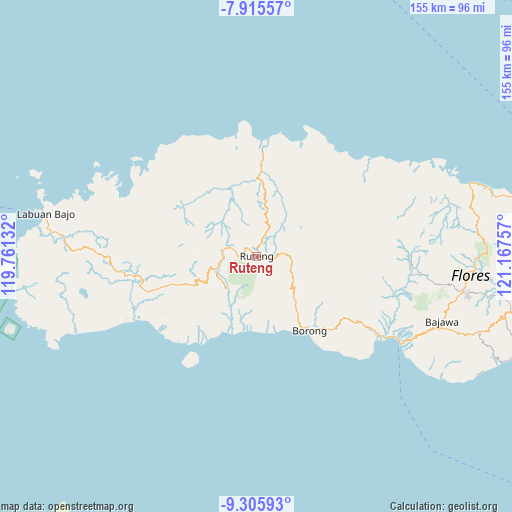
Ruteng GPS coordinates[2]
8° 36' 41.004" South, 120° 27' 51.984" East
| Map corner | latitude | longitude |
|---|---|---|
| Upper-left | -7.91557°, | 119.76132° |
| Center: | -8.61139°, | 120.46444° |
| Lower-right: | -9.30593°, | 121.16757° |
| Map W x H: | 154.6×154.6 km | = 96.1×96.1mi |
| max Lat: | 5.88969° ⇑87.1% North |
| Ruteng: | -8.61139° |
| min Lat: | ⇓12.9% South -10.934° |
| min Long | Ruteng | max Long |
| 95.1345° | 120.46444° | 140.9419° |
| W 84.2%⇐ | ⇒15.8% E |
Elevation
Elevation of Ruteng is 1173 m = 3848 ft, and this is 943.3 m = 3095 ft above average elevation for this country.
| Max E: |
3185 m = 10449 ft | 1.2% |
| Ruteng | 1173 m 3848 ft | |
| Avg. | 229.7 m = 754 ft | |
Min E: |
-1 m = -3 ft | 98.8% |
See also: Indonesia elevation on elevation.city.
Geographical zone
Ruteng is located in South Torrid zone (between Equator and Tropic of Capricorn). Distance of Equator is 957.5 km =595 mi to North.| Distance of | km | miles | from Ruteng |
|---|---|---|---|
| Equator | 957.5 | 595 | to North |
| Tropic Capricorn | 1648.4 | 1024.3 | to South |
| Antarctic Circle | 6443.7 | 4003.9 | to South |
| South Pole | 9049.6 | 5623.2 | to South |


Nearby cities:
15 places around Ruteng: (largest is in red/bold)
• Biting
18.7 km =11.6 mi,  84°
84°
• Bombu
10.5 km =6.5 mi,  147°
147°
• Golomunta
17.3 km =10.7 mi,  17°
17°
• Kaca
18.2 km =11.3 mi,  139°
139°
• Kawit
15.6 km =9.7 mi, 141°
• Kenca
18.6 km =11.6 mi,  33°
33°
• Moso
15.7 km =9.8 mi, 19°
• Ntaur Satu
11.4 km =7.1 mi, 141°
• Ponggeok
13.6 km =8.5 mi,  203°
203°
• Pongkor
14.2 km =8.8 mi,  216°
216°
• Pora
14 km =8.7 mi, 219°
• Rentung
13 km =8.1 mi,  122°
122°
• Tado
17.6 km =10.9 mi, 124°
• Teber
15.1 km =9.4 mi,  109°
109°
• Wasogolo
1.8 km =1.1 mi, 196°
Sources, notices
• [Note1] Compared only with cities in Indonesia existing in our database
• [Src1] Map data: © OpenStreetMap contributors (CC-BY-SA)
• [Src2] Other city data from geonames.org with taken over terms of usage.
• [Src3] Geographical zone / Annual Mean Temperature by Robert A. Rohde @ Wikipedia
