Pecatu geodata
Pecatu (Bali) is a seat of a fourth-order administrative division; located in Indonesia in Asia/Makassar (GMT+8) time zone. In our database, there are 407 cities with bigger population. Compared to other cities in Indonesia, 91.9% of cities are located further ↑North; 71.8% of cities are located further ←West and 61.8% of cities have lower elevation than Pecatu. Note1


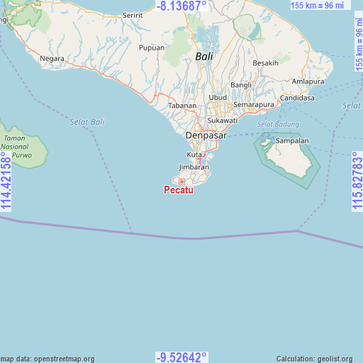
Pecatu GPS coordinates[2]
8° 49' 56.28" South, 115° 7' 28.92" East
| Map corner | latitude | longitude |
|---|---|---|
| Upper-left | -8.13687°, | 114.42158° |
| Center: | -8.8323°, | 115.1247° |
| Lower-right: | -9.52642°, | 115.82783° |
| Map W x H: | 154.5×154.5 km | = 96×96mi |
| max Lat: | 5.88969° ⇑91.9% North |
| Pecatu: | -8.8323° |
| min Lat: | ⇓8.1% South -10.934° |
| min Long | Pecatu | max Long |
| 95.1345° | 115.1247° | 140.9419° |
| W 71.8%⇐ | ⇒28.2% E |
Elevation
Elevation of Pecatu is 183 m = 600 ft, and this is 46.7 m = 153 ft below average elevation for this country.
| Max E: |
3185 m = 10449 ft | 38.2% |
| Avg. | 229.7 m = 754 ft | |
| Pecatu | 183 m = 600 ft | |
Min E: |
-1 m = -3 ft | 61.8% |
See also: Indonesia elevation on elevation.city.
Geographical zone
Pecatu is located in South Torrid zone (between Equator and Tropic of Capricorn). Distance of Equator is 982.1 km =610.2 mi to North.| Distance of | km | miles | from Pecatu |
|---|---|---|---|
| Equator | 982.1 | 610.2 | to North |
| Tropic Capricorn | 1623.9 | 1009 | to South |
| Antarctic Circle | 6419.1 | 3988.6 | to South |
| South Pole | 9025 | 5607.9 | to South |


Nearby cities:
15 places around Pecatu: (largest is in red/bold)
• Banjar Batanpoh
22.7 km =14.1 mi,  40°
40°
• Banjar Gunungpande
24.2 km =15 mi,  5°
5°
• Banjar Kerobokan
23.8 km =14.8 mi,  0°
0°
• Banjar Medura
21 km =13 mi, 42°
• Banjar Taman
22.1 km =13.7 mi, 40°
• Bualu
10.9 km =6.8 mi,  68°
68°
• Denpasar
22.7 km =14.1 mi,  26°
26°
• Jabajero
12.9 km =8 mi, 25°
• Jimbaran
6 km =3.7 mi, 40°
• Kangin
0.3 km =0.2 mi,  116°
116°
• Karyadharma
17.6 km =10.9 mi, 35°
• Kelanabian
10.6 km =6.6 mi, 32°
• Kuta
13.2 km =8.2 mi,  23°
23°
• Legian
15.1 km =9.4 mi, 19°
• Nusa Dua
12.5 km =7.8 mi, 73°
Sources, notices
• [Note1] Compared only with cities in Indonesia existing in our database
• [Src1] Map data: © OpenStreetMap contributors (CC-BY-SA)
• [Src2] Other city data from geonames.org with taken over terms of usage.
• [Src3] Geographical zone / Annual Mean Temperature by Robert A. Rohde @ Wikipedia
