Panacaran geodata
Panacaran (Banten) is a seat of a fourth-order administrative division; located in Indonesia in Asia/Jakarta (GMT+7) time zone. In our database, there are 407 cities with bigger population. Compared to other cities in Indonesia, 81.6% of cities are located further ↓South; 92% of cities are located further →East and 57.7% of cities have higher elevation than Panacaran. Note1


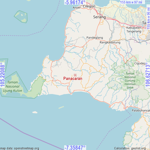
Panacaran GPS coordinates[2]
6° 39' 38.16" South, 105° 55' 26.4" East
| Map corner | latitude | longitude |
|---|---|---|
| Upper-left | -5.96174°, | 105.22088° |
| Center: | -6.6606°, | 105.924° |
| Lower-right: | -7.35847°, | 106.62713° |
| Map W x H: | 155.3×155.3 km | = 96.5×96.5mi |
| max Lat: | 5.88969° ⇑18.4% North |
| Panacaran: | -6.6606° |
| min Lat: | ⇓81.6% South -10.934° |
| min Long | Panacaran | max Long |
| 95.1345° | 105.924° | 140.9419° |
| W 8%⇐ | ⇒92% E |
Elevation
Elevation of Panacaran is 69 m = 226 ft, and this is 160.7 m = 527 ft below average elevation for this country.
| Max E: |
3185 m = 10449 ft | 57.7% |
| Avg. | 229.7 m = 754 ft | |
| Panacaran | 69 m = 226 ft | |
Min E: |
-1 m = -3 ft | 42.3% |
See also: Indonesia elevation on elevation.city.
Geographical zone
Panacaran is located in South Torrid zone (between Equator and Tropic of Capricorn). Distance of Equator is 740.6 km =460.2 mi to North.| Distance of | km | miles | from Panacaran |
|---|---|---|---|
| Equator | 740.6 | 460.2 | to North |
| Tropic Capricorn | 1865.3 | 1159 | to South |
| Antarctic Circle | 6660.6 | 4138.7 | to South |
| South Pole | 9266.5 | 5757.9 | to South |


Nearby cities:
15 places around Panacaran: (largest is in red/bold)
• Cibeureum
6.9 km =4.3 mi,  356°
356°
• Cibitungmasjid
6.3 km =3.9 mi,  321°
321°
• Cigalih
3.3 km =2.1 mi,  259°
259°
• Cikaludan
6.4 km =4 mi,  215°
215°
• Cikarang
6.2 km =3.9 mi,  183°
183°
• Cipaas
5.2 km =3.2 mi,  204°
204°
• Curuglanglang
3.4 km =2.1 mi,  352°
352°
• Kadubadak
7.1 km =4.4 mi,  281°
281°
• Kampungsawah
6 km =3.7 mi,  106°
106°
• Kotadukuh
7.4 km =4.6 mi,  342°
342°
• Lebak
5.8 km =3.6 mi,  292°
292°
• Lebakkeusik
7.3 km =4.5 mi,  24°
24°
• Munjul
6.2 km =3.9 mi,  333°
333°
• Pasanggrahan
6.5 km =4 mi, 340°
• Perumahan Kopi
4.5 km =2.8 mi, 114°
Sources, notices
• [Note1] Compared only with cities in Indonesia existing in our database
• [Src1] Map data: © OpenStreetMap contributors (CC-BY-SA)
• [Src2] Other city data from geonames.org with taken over terms of usage.
• [Src3] Geographical zone / Annual Mean Temperature by Robert A. Rohde @ Wikipedia
