Tanahbeureum geodata
Tanahbeureum (West Java) is a seat of a fourth-order administrative division; located in Indonesia in Asia/Jakarta (GMT+7) time zone. In our database, there are 407 cities with bigger population. Compared to other cities in Indonesia, 59.8% of cities are located further ↓South; 85.7% of cities are located further →East and 94.5% of cities have lower elevation than Tanahbeureum. Note1


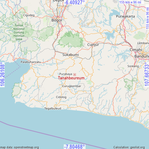
Tanahbeureum GPS coordinates[2]
7° 6' 27" South, 106° 57' 51.12" East
| Map corner | latitude | longitude |
|---|---|---|
| Upper-left | -6.40927°, | 106.26108° |
| Center: | -7.1075°, | 106.9642° |
| Lower-right: | -7.80468°, | 107.66733° |
| Map W x H: | 155.2×155.2 km | = 96.4×96.4mi |
| max Lat: | 5.88969° ⇑40.2% North |
| Tanahbeureum: | -7.1075° |
| min Lat: | ⇓59.8% South -10.934° |
| min Long | Tanahbeureum | max Long |
| 95.1345° | 106.9642° | 140.9419° |
| W 14.3%⇐ | ⇒85.7% E |
Elevation
Elevation of Tanahbeureum is 791 m = 2595 ft, and this is 561.3 m = 1842 ft above average elevation for this country.
| Max E: |
3185 m = 10449 ft | 5.5% |
| Tanahbeureum | 791 m 2595 ft | |
| Avg. | 229.7 m = 754 ft | |
Min E: |
-1 m = -3 ft | 94.5% |
See also: Indonesia elevation on elevation.city.
Geographical zone
Tanahbeureum is located in South Torrid zone (between Equator and Tropic of Capricorn). Distance of Equator is 790.3 km =491.1 mi to North.| Distance of | km | miles | from Tanahbeureum |
|---|---|---|---|
| Equator | 790.3 | 491.1 | to North |
| Tropic Capricorn | 1815.6 | 1128.2 | to South |
| Antarctic Circle | 6610.9 | 4107.8 | to South |
| South Pole | 9216.8 | 5727.1 | to South |


Nearby cities:
15 places around Tanahbeureum: (largest is in red/bold)
• Babakanbandung
7 km =4.3 mi,  79°
79°
• Bungbangsari
5.1 km =3.2 mi,  19°
19°
• Cibiru
4.7 km =2.9 mi,  281°
281°
• Cigawir
8 km =5 mi,  293°
293°
• Cisantri
7.3 km =4.5 mi,  314°
314°
• Dampit Satu
6.3 km =3.9 mi,  153°
153°
• Kalibaru
9.3 km =5.8 mi,  67°
67°
• Liunggunung
9 km =5.6 mi,  340°
340°
• Nyalindung
7.5 km =4.7 mi, 342°
• Pasirawi
1.8 km =1.1 mi, 312°
• Simpang
5.7 km =3.5 mi,  130°
130°
• Sindangraja
3.4 km =2.1 mi,  269°
269°
• Sukamahi Satu
8 km =5 mi,  107°
107°
• Sukamaju
7.4 km =4.6 mi,  192°
192°
• Takokak
7.6 km =4.7 mi,  34°
34°
Sources, notices
• [Note1] Compared only with cities in Indonesia existing in our database
• [Src1] Map data: © OpenStreetMap contributors (CC-BY-SA)
• [Src2] Other city data from geonames.org with taken over terms of usage.
• [Src3] Geographical zone / Annual Mean Temperature by Robert A. Rohde @ Wikipedia
