Nuhawala geodata
Nuhawala (East Nusa Tenggara) is a seat of a fourth-order administrative division; located in Indonesia in Asia/Makassar (GMT+8) time zone. In our database, there are 407 cities with bigger population. Compared to other cities in Indonesia, 79.6% of cities are located further ↑North; 95% of cities are located further ←West and 79.9% of cities have higher elevation than Nuhawala. Note1


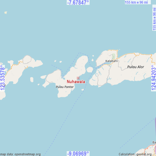
Nuhawala GPS coordinates[2]
8° 22' 28.92" South, 124° 14' 20.04" East
| Map corner | latitude | longitude |
|---|---|---|
| Upper-left | -7.67847°, | 123.53578° |
| Center: | -8.3747°, | 124.2389° |
| Lower-right: | -9.06969°, | 124.94203° |
| Map W x H: | 154.7×154.7 km | = 96.1×96.1mi |
| max Lat: | 5.88969° ⇑79.6% North |
| Nuhawala: | -8.3747° |
| min Lat: | ⇓20.4% South -10.934° |
| min Long | Nuhawala | max Long |
| 95.1345° | 124.2389° | 140.9419° |
| W 95%⇐ | ⇒5% E |
Elevation
Elevation of Nuhawala is 19 m = 62 ft, and this is 210.7 m = 691 ft below average elevation for this country.
| Max E: |
3185 m = 10449 ft | 79.9% |
| Avg. | 229.7 m = 754 ft | |
| Nuhawala | 19 m = 62 ft | |
Min E: |
-1 m = -3 ft | 20.1% |
See also: Indonesia elevation on elevation.city.
Geographical zone
Nuhawala is located in South Torrid zone (between Equator and Tropic of Capricorn). Distance of Equator is 931.2 km =578.6 mi to North.| Distance of | km | miles | from Nuhawala |
|---|---|---|---|
| Equator | 931.2 | 578.6 | to North |
| Tropic Capricorn | 1674.7 | 1040.6 | to South |
| Antarctic Circle | 6470 | 4020.3 | to South |
| South Pole | 9075.9 | 5639.5 | to South |


Nearby cities:
15 places around Nuhawala: (largest is in red/bold)
• Apuri
15.3 km =9.5 mi,  64°
64°
• Bakalang
13.8 km =8.6 mi,  28°
28°
• Baranusa
16.6 km =10.3 mi,  274°
274°
• Kabir
13.6 km =8.5 mi,  348°
348°
• Latuna
20.2 km =12.6 mi,  264°
264°
• Maliang
11.9 km =7.4 mi, 265°
• Mataraben
19.6 km =12.2 mi,  89°
89°
• Mauta
15.4 km =9.6 mi,  230°
230°
• Pandai
20.7 km =12.9 mi,  6°
6°
• Pantaimakasar
22.1 km =13.7 mi, 58°
• Puntaru
22 km =13.7 mi,  247°
247°
• Solangbali
16.3 km =10.1 mi,  47°
47°
• Tamalabang
3.2 km =2 mi,  39°
39°
• Tobitambor
14.4 km =8.9 mi, 351°
• Ulimonong
23.7 km =14.7 mi, 50°
Sources, notices
• [Note1] Compared only with cities in Indonesia existing in our database
• [Src1] Map data: © OpenStreetMap contributors (CC-BY-SA)
• [Src2] Other city data from geonames.org with taken over terms of usage.
• [Src3] Geographical zone / Annual Mean Temperature by Robert A. Rohde @ Wikipedia
