Latuna geodata
Latuna (East Nusa Tenggara) is a seat of a fourth-order administrative division; located in Indonesia in Asia/Makassar (GMT+8) time zone. In our database, there are 407 cities with bigger population. Compared to other cities in Indonesia, 80.1% of cities are located further ↑North; 94.5% of cities are located further ←West and 53.7% of cities have lower elevation than Latuna. Note1


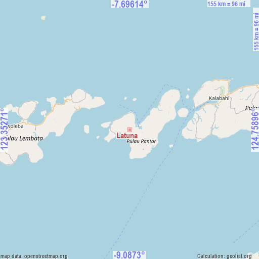
Latuna GPS coordinates[2]
8° 23' 32.424" South, 124° 3' 20.988" East
| Map corner | latitude | longitude |
|---|---|---|
| Upper-left | -7.69614°, | 123.35271° |
| Center: | -8.39234°, | 124.05583° |
| Lower-right: | -9.0873°, | 124.75896° |
| Map W x H: | 154.7×154.7 km | = 96.1×96.1mi |
| max Lat: | 5.88969° ⇑80.1% North |
| Latuna: | -8.39234° |
| min Lat: | ⇓19.9% South -10.934° |
| min Long | Latuna | max Long |
| 95.1345° | 124.05583° | 140.9419° |
| W 94.5%⇐ | ⇒5.5% E |
Elevation
Elevation of Latuna is 118 m = 387 ft, and this is 111.7 m = 366 ft below average elevation for this country.
| Max E: |
3185 m = 10449 ft | 46.3% |
| Avg. | 229.7 m = 754 ft | |
| Latuna | 118 m = 387 ft | |
Min E: |
-1 m = -3 ft | 53.7% |
See also: Indonesia elevation on elevation.city.
Geographical zone
Latuna is located in South Torrid zone (between Equator and Tropic of Capricorn). Distance of Equator is 933.1 km =579.8 mi to North.| Distance of | km | miles | from Latuna |
|---|---|---|---|
| Equator | 933.1 | 579.8 | to North |
| Tropic Capricorn | 1672.8 | 1039.4 | to South |
| Antarctic Circle | 6468 | 4019 | to South |
| South Pole | 9073.9 | 5638.3 | to South |


Nearby cities:
15 places around Latuna: (largest is in red/bold)
• Bakalang
30.2 km =18.8 mi,  62°
62°
• Baranusa
4.9 km =3 mi,  47°
47°
• Kabir
23.2 km =14.4 mi, 48°
• Leudawan
32.8 km =20.4 mi,  305°
305°
• Leutubung Satu
32.7 km =20.3 mi,  303°
303°
• Maliang
8.3 km =5.2 mi,  82°
82°
• Marica
11 km =6.8 mi, 296°
• Mauta
11.4 km =7.1 mi,  133°
133°
• Nuhawala
20.2 km =12.6 mi, 84°
• Pandai
31.9 km =19.8 mi, 45°
• Puntaru
6.4 km =4 mi,  181°
181°
• Roun Satu
32.7 km =20.3 mi, 305°
• Tamalabang
22.6 km =14 mi, 78°
• Tobitambor
24.3 km =15.1 mi, 48°
• Weikoro
33 km =20.5 mi, 310°
Sources, notices
• [Note1] Compared only with cities in Indonesia existing in our database
• [Src1] Map data: © OpenStreetMap contributors (CC-BY-SA)
• [Src2] Other city data from geonames.org with taken over terms of usage.
• [Src3] Geographical zone / Annual Mean Temperature by Robert A. Rohde @ Wikipedia
