Pesawahan geodata
Pesawahan (Central Java) is a seat of a fourth-order administrative division; located in Indonesia in Asia/Jakarta (GMT+7) time zone. In our database, there are 407 cities with bigger population. Compared to other cities in Indonesia, 56.6% of cities are located further ↑North; 66.4% of cities are located further →East and 80.9% of cities have higher elevation than Pesawahan. Note1


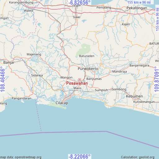
Pesawahan GPS coordinates[2]
7° 31' 27.012" South, 109° 10' 4.008" East
| Map corner | latitude | longitude |
|---|---|---|
| Upper-left | -6.82656°, | 108.46466° |
| Center: | -7.52417°, | 109.16778° |
| Lower-right: | -8.22066°, | 109.87091° |
| Map W x H: | 155×155 km | = 96.3×96.3mi |
| max Lat: | 5.88969° ⇑56.6% North |
| Pesawahan: | -7.52417° |
| min Lat: | ⇓43.4% South -10.934° |
| min Long | Pesawahan | max Long |
| 95.1345° | 109.16778° | 140.9419° |
| W 33.6%⇐ | ⇒66.4% E |
Elevation
Elevation of Pesawahan is 18 m = 59 ft, and this is 211.7 m = 695 ft below average elevation for this country.
| Max E: |
3185 m = 10449 ft | 80.9% |
| Avg. | 229.7 m = 754 ft | |
| Pesawahan | 18 m = 59 ft | |
Min E: |
-1 m = -3 ft | 19.1% |
See also: Indonesia elevation on elevation.city.
Geographical zone
Pesawahan is located in South Torrid zone (between Equator and Tropic of Capricorn). Distance of Equator is 836.6 km =519.8 mi to North.| Distance of | km | miles | from Pesawahan |
|---|---|---|---|
| Equator | 836.6 | 519.8 | to North |
| Tropic Capricorn | 1769.3 | 1099.4 | to South |
| Antarctic Circle | 6564.6 | 4079.1 | to South |
| South Pole | 9170.5 | 5698.3 | to South |


Nearby cities:
15 places around Pesawahan: (largest is in red/bold)
• Brani
4 km =2.5 mi,  164°
164°
• Gambarjati
4.5 km =2.8 mi,  251°
251°
• Gambarsari
3.8 km =2.4 mi,  102°
102°
• Jatilawang
5.4 km =3.4 mi,  257°
257°
• Karanglewas
4.6 km =2.9 mi,  224°
224°
• Karangtengah
5.2 km =3.2 mi,  152°
152°
• Kebasen
3.7 km =2.3 mi,  106°
106°
• Losari
4 km =2.5 mi,  201°
201°
• Margasana
3.6 km =2.2 mi,  244°
244°
• Menganti
3.1 km =1.9 mi, 204°
• Rawalo
1.9 km =1.2 mi,  138°
138°
• Sampang
5.4 km =3.4 mi, 143°
• Tinggarwangi
5 km =3.1 mi,  270°
270°
• Tipar
3 km =1.9 mi,  314°
314°
• Tugu
3.5 km =2.2 mi,  287°
287°
Sources, notices
• [Note1] Compared only with cities in Indonesia existing in our database
• [Src1] Map data: © OpenStreetMap contributors (CC-BY-SA)
• [Src2] Other city data from geonames.org with taken over terms of usage.
• [Src3] Geographical zone / Annual Mean Temperature by Robert A. Rohde @ Wikipedia
