Bakung geodata
Bakung (Central Java) is a seat of a fourth-order administrative division; located in Indonesia in Asia/Jakarta (GMT+7) time zone. In our database, there are 407 cities with bigger population. Compared to other cities in Indonesia, 51.4% of cities are located further ↑North; 69.1% of cities are located further →East and 78.9% of cities have higher elevation than Bakung. Note1


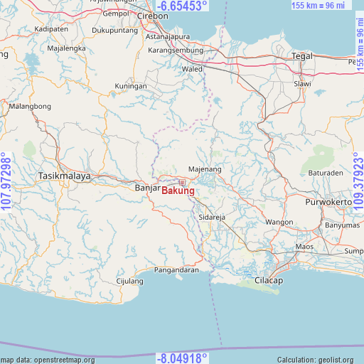
Bakung GPS coordinates[2]
7° 21' 8.64" South, 108° 40' 33.96" East
| Map corner | latitude | longitude |
|---|---|---|
| Upper-left | -6.65453°, | 107.97298° |
| Center: | -7.3524°, | 108.6761° |
| Lower-right: | -8.04918°, | 109.37923° |
| Map W x H: | 155.1×155.1 km | = 96.4×96.4mi |
| max Lat: | 5.88969° ⇑51.4% North |
| Bakung: | -7.3524° |
| min Lat: | ⇓48.6% South -10.934° |
| min Long | Bakung | max Long |
| 95.1345° | 108.6761° | 140.9419° |
| W 30.9%⇐ | ⇒69.1% E |
Elevation
Elevation of Bakung is 20 m = 66 ft, and this is 209.7 m = 688 ft below average elevation for this country.
| Max E: |
3185 m = 10449 ft | 78.9% |
| Avg. | 229.7 m = 754 ft | |
| Bakung | 20 m = 66 ft | |
Min E: |
-1 m = -3 ft | 21.1% |
See also: Indonesia elevation on elevation.city.
Geographical zone
Bakung is located in South Torrid zone (between Equator and Tropic of Capricorn). Distance of Equator is 817.5 km =508 mi to North.| Distance of | km | miles | from Bakung |
|---|---|---|---|
| Equator | 817.5 | 508 | to North |
| Tropic Capricorn | 1788.4 | 1111.3 | to South |
| Antarctic Circle | 6583.7 | 4090.9 | to South |
| South Pole | 9189.6 | 5710.2 | to South |


Nearby cities:
15 places around Bakung: (largest is in red/bold)
• Babakan
4.2 km =2.6 mi,  249°
249°
• Cihandiwung Lor
2.6 km =1.6 mi,  36°
36°
• Cintaratu
2.1 km =1.3 mi,  171°
171°
• Kalapagada
4.9 km =3 mi,  199°
199°
• Karanganyar
4.1 km =2.5 mi,  304°
304°
• Majingklak
5.3 km =3.3 mi,  359°
359°
• Malabar
5.5 km =3.4 mi,  11°
11°
• Meluwung
5.4 km =3.4 mi,  148°
148°
• Pondokunyur
4 km =2.5 mi,  180°
180°
• Sinargalih
4.2 km =2.6 mi,  262°
262°
• Sogati
2.8 km =1.7 mi,  16°
16°
• Sukahurip
4.4 km =2.7 mi,  270°
270°
• Tambakreja
4 km =2.5 mi,  212°
212°
• Wanareja
2.5 km =1.6 mi,  30°
30°
• Winangun
3 km =1.9 mi,  100°
100°
Sources, notices
• [Note1] Compared only with cities in Indonesia existing in our database
• [Src1] Map data: © OpenStreetMap contributors (CC-BY-SA)
• [Src2] Other city data from geonames.org with taken over terms of usage.
• [Src3] Geographical zone / Annual Mean Temperature by Robert A. Rohde @ Wikipedia
