Maumere geodata
Maumere (East Nusa Tenggara) is a seat of a second-order administrative division; located in Indonesia in Asia/Makassar (GMT+8) time zone. With population of 47,598 people, there are 246 cities with bigger population in this country. Compared to other cities in Indonesia, 87.4% of cities are located further ↑North; 88.5% of cities are located further ←West and 80.9% of cities have higher elevation than Maumere. Note1


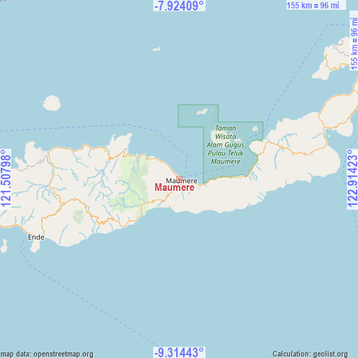
Maumere GPS coordinates[2]
8° 37' 11.64" South, 122° 12' 39.96" East
| Map corner | latitude | longitude |
|---|---|---|
| Upper-left | -7.92409°, | 121.50798° |
| Center: | -8.6199°, | 122.2111° |
| Lower-right: | -9.31443°, | 122.91423° |
| Map W x H: | 154.6×154.6 km | = 96.1×96.1mi |
| max Lat: | 5.88969° ⇑87.4% North |
| Maumere: | -8.6199° |
| min Lat: | ⇓12.6% South -10.934° |
| min Long | Maumere | max Long |
| 95.1345° | 122.2111° | 140.9419° |
| W 88.5%⇐ | ⇒11.5% E |
Elevation
Elevation of Maumere is 18 m = 59 ft, and this is 211.7 m = 695 ft below average elevation for this country.
| Max E: |
3185 m = 10449 ft | 80.9% |
| Avg. | 229.7 m = 754 ft | |
| Maumere | 18 m = 59 ft | |
Min E: |
-1 m = -3 ft | 19.1% |
See also: Maumere elevation on elevation.city.
Geographical zone
Maumere is located in South Torrid zone (between Equator and Tropic of Capricorn). Distance of Equator is 958.4 km =595.5 mi to North.| Distance of | km | miles | from Maumere |
|---|---|---|---|
| Equator | 958.4 | 595.5 | to North |
| Tropic Capricorn | 1647.5 | 1023.7 | to South |
| Antarctic Circle | 6442.7 | 4003.3 | to South |
| South Pole | 9048.6 | 5622.5 | to South |


Nearby cities:
15 places around Maumere: (largest is in red/bold)
• Brai
4.7 km =2.9 mi,  158°
158°
• Detung
4.9 km =3 mi,  174°
174°
• Halat
7.1 km =4.4 mi,  183°
183°
• Kabor
0.4 km =0.2 mi,  101°
101°
• Kotauneng
0.7 km =0.4 mi,  48°
48°
• Kotingnatagete
7.1 km =4.4 mi,  196°
196°
• Nangahure
7.5 km =4.7 mi,  318°
318°
• Nangalimang
3.1 km =1.9 mi,  190°
190°
• Nele
6.3 km =3.9 mi, 176°
• Ritapiret
7 km =4.3 mi,  214°
214°
• Tadabliro
7.2 km =4.5 mi, 175°
• Urungpigang
3.2 km =2 mi,  305°
305°
• Waioti
3.5 km =2.2 mi,  110°
110°
• Watuliwung
6.4 km =4 mi,  131°
131°
• Wolomarang
2.2 km =1.4 mi, 323°
Sources, notices
• [Note1] Compared only with cities in Indonesia existing in our database
• [Src1] Map data: © OpenStreetMap contributors (CC-BY-SA)
• [Src2] Other city data from geonames.org with taken over terms of usage.
• [Src3] Geographical zone / Annual Mean Temperature by Robert A. Rohde @ Wikipedia
