Kabor geodata
Kabor (East Nusa Tenggara) is a seat of a fourth-order administrative division; located in Indonesia in Asia/Makassar (GMT+8) time zone. In our database, there are 407 cities with bigger population. Compared to other cities in Indonesia, 87.4% of cities are located further ↑North; 88.5% of cities are located further ←West and 85.2% of cities have higher elevation than Kabor. Note1


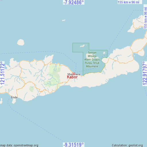
Kabor GPS coordinates[2]
8° 37' 14.376" South, 122° 12' 53.424" East
| Map corner | latitude | longitude |
|---|---|---|
| Upper-left | -7.92486°, | 121.51172° |
| Center: | -8.62066°, | 122.21484° |
| Lower-right: | -9.31519°, | 122.91797° |
| Map W x H: | 154.6×154.6 km | = 96.1×96.1mi |
| max Lat: | 5.88969° ⇑87.4% North |
| Kabor: | -8.62066° |
| min Lat: | ⇓12.6% South -10.934° |
| min Long | Kabor | max Long |
| 95.1345° | 122.21484° | 140.9419° |
| W 88.5%⇐ | ⇒11.5% E |
Elevation
Elevation of Kabor is 14 m = 46 ft, and this is 215.7 m = 708 ft below average elevation for this country.
| Max E: |
3185 m = 10449 ft | 85.2% |
| Avg. | 229.7 m = 754 ft | |
| Kabor | 14 m = 46 ft | |
Min E: |
-1 m = -3 ft | 14.8% |
See also: Indonesia elevation on elevation.city.
Geographical zone
Kabor is located in South Torrid zone (between Equator and Tropic of Capricorn). Distance of Equator is 958.5 km =595.6 mi to North.| Distance of | km | miles | from Kabor |
|---|---|---|---|
| Equator | 958.5 | 595.6 | to North |
| Tropic Capricorn | 1647.4 | 1023.6 | to South |
| Antarctic Circle | 6442.6 | 4003.2 | to South |
| South Pole | 9048.5 | 5622.5 | to South |


Nearby cities:
15 places around Kabor: (largest is in red/bold)
• Brai
4.4 km =2.7 mi,  163°
163°
• Detung
4.8 km =3 mi,  178°
178°
• Halat
7 km =4.3 mi,  186°
186°
• Higetegera
7.1 km =4.4 mi,  113°
113°
• Kotauneng
0.6 km =0.4 mi,  12°
12°
• Kotingnatagete
7.2 km =4.5 mi,  199°
199°
• Maumere
0.4 km =0.2 mi,  281°
281°
• Nangalimang
3.1 km =1.9 mi, 198°
• Nele
6.2 km =3.9 mi, 180°
• Ritapiret
7.2 km =4.5 mi,  217°
217°
• Tadabliro
7.1 km =4.4 mi, 178°
• Urungpigang
3.5 km =2.2 mi,  302°
302°
• Waioti
3.1 km =1.9 mi, 111°
• Watuliwung
6 km =3.7 mi,  133°
133°
• Wolomarang
2.5 km =1.6 mi,  317°
317°
Sources, notices
• [Note1] Compared only with cities in Indonesia existing in our database
• [Src1] Map data: © OpenStreetMap contributors (CC-BY-SA)
• [Src2] Other city data from geonames.org with taken over terms of usage.
• [Src3] Geographical zone / Annual Mean Temperature by Robert A. Rohde @ Wikipedia
