Maduran geodata
Maduran (East Java) is a seat of a fourth-order administrative division; located in Indonesia in Asia/Jakarta (GMT+7) time zone. In our database, there are 407 cities with bigger population. Compared to other cities in Indonesia, 65.7% of cities are located further ↓South; 51.9% of cities are located further ←West and 92.1% of cities have higher elevation than Maduran. Note1


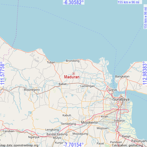
Maduran GPS coordinates[2]
7° 0' 15.12" South, 112° 16' 50.52" East
| Map corner | latitude | longitude |
|---|---|---|
| Upper-left | -6.30582°, | 111.57758° |
| Center: | -7.0042°, | 112.2807° |
| Lower-right: | -7.70154°, | 112.98383° |
| Map W x H: | 155.2×155.2 km | = 96.4×96.4mi |
| max Lat: | 5.88969° ⇑34.3% North |
| Maduran: | -7.0042° |
| min Lat: | ⇓65.7% South -10.934° |
| min Long | Maduran | max Long |
| 95.1345° | 112.2807° | 140.9419° |
| W 51.9%⇐ | ⇒48.1% E |
Elevation
Elevation of Maduran is 9 m = 30 ft, and this is 220.7 m = 724 ft below average elevation for this country.
| Max E: |
3185 m = 10449 ft | 92.1% |
| Avg. | 229.7 m = 754 ft | |
| Maduran | 9 m = 30 ft | |
Min E: |
-1 m = -3 ft | 7.9% |
See also: Indonesia elevation on elevation.city.
Geographical zone
Maduran is located in South Torrid zone (between Equator and Tropic of Capricorn). Distance of Equator is 778.8 km =483.9 mi to North.| Distance of | km | miles | from Maduran |
|---|---|---|---|
| Equator | 778.8 | 483.9 | to North |
| Tropic Capricorn | 1827.1 | 1135.3 | to South |
| Antarctic Circle | 6622.4 | 4115 | to South |
| South Pole | 9228.3 | 5734.2 | to South |


Nearby cities:
15 places around Maduran: (largest is in red/bold)
• Blumbang
4.7 km =2.9 mi,  41°
41°
• Gampang
5.7 km =3.5 mi,  20°
20°
• Gedangan
4.4 km =2.7 mi,  27°
27°
• Jabung
5.7 km =3.5 mi,  278°
278°
• Jangkungkusumo
1.9 km =1.2 mi,  12°
12°
• Kaligerman
5.4 km =3.4 mi,  83°
83°
• Kanugrahan
2.4 km =1.5 mi,  55°
55°
• Karangrejo
4.7 km =2.9 mi,  74°
74°
• Laren
3.4 km =2.1 mi, 29°
• Pangkatrejo
2.8 km =1.7 mi, 26°
• Parengan
2.5 km =1.6 mi, 14°
• Pelangwot
2.1 km =1.3 mi,  355°
355°
• Pringgoboyo
3.1 km =1.9 mi, 35°
• Taman
4.8 km =3 mi,  51°
51°
• Turi
3.2 km =2 mi, 54°
Sources, notices
• [Note1] Compared only with cities in Indonesia existing in our database
• [Src1] Map data: © OpenStreetMap contributors (CC-BY-SA)
• [Src2] Other city data from geonames.org with taken over terms of usage.
• [Src3] Geographical zone / Annual Mean Temperature by Robert A. Rohde @ Wikipedia
