Lolak geodata
Lolak (North Sulawesi) is a seat of a second-order administrative division; located in Indonesia in Asia/Makassar (GMT+8) time zone. In our database, there are 407 cities with bigger population. Compared to other cities in Indonesia, 96% of cities are located further ↓South; 94.4% of cities are located further ←West and 90.6% of cities have higher elevation than Lolak. Note1


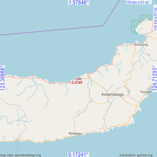
Lolak GPS coordinates[2]
0° 52' 31.8" North, 124° 0' 35.28" East
| Map corner | latitude | longitude |
|---|---|---|
| Upper-left | 1.57846°, | 123.30668° |
| Center: | 0.8755°, | 124.0098° |
| Lower-right: | 0.17241°, | 124.71293° |
| Map W x H: | 156.3×156.3 km | = 97.1×97.1mi |
| max Lat: | 5.88969° ⇑4% North |
| Lolak: | 0.8755° |
| min Lat: | ⇓96% South -10.934° |
| min Long | Lolak | max Long |
| 95.1345° | 124.0098° | 140.9419° |
| W 94.4%⇐ | ⇒5.6% E |
Elevation
Elevation of Lolak is 10 m = 33 ft, and this is 219.7 m = 721 ft below average elevation for this country.
| Max E: |
3185 m = 10449 ft | 90.6% |
| Avg. | 229.7 m = 754 ft | |
| Lolak | 10 m = 33 ft | |
Min E: |
-1 m = -3 ft | 9.4% |
See also: Indonesia elevation on elevation.city.
Geographical zone
Lolak is located in North Torrid zone (between Equator and Tropic of Cancer). Distance of Equator is 97.3 km =60.5 mi to South.| Distance of | km | miles | from Lolak |
|---|---|---|---|
| North Pole | 9909.7 | 6157.6 | to North |
| Arctic Circle | 7303.8 | 4538.4 | to North |
| Tropic Cancer | 2508.6 | 1558.8 | to North |
| Equator | 97.3 | 60.5 | to South |


Nearby cities:
15 places around Lolak: (largest is in red/bold)
• Bilalang
34.3 km =21.3 mi,  109°
109°
• Bolaang
17.8 km =11.1 mi,  65°
65°
• Dumoga
30.7 km =19.1 mi,  164°
164°
• Kotabunan
72.1 km =44.8 mi,  95°
95°
• Lolayan
41.8 km =26 mi,  127°
127°
• Modayag
45.4 km =28.2 mi, 113°
• Molibagu
54.5 km =33.9 mi,  183°
183°
• Passi
34.3 km =21.3 mi, 110°
• Pimpi
51.1 km =31.8 mi,  270°
270°
• Poigar
33.2 km =20.6 mi, 66°
• Poigar
37 km =23 mi,  64°
64°
• Tenga
57.4 km =35.7 mi, 56°
• Tompasobaru
51.3 km =31.9 mi,  84°
84°
• Tungoo
31.4 km =19.5 mi,  117°
117°
• Tutuyan
68.3 km =42.4 mi, 100°
Sources, notices
• [Note1] Compared only with cities in Indonesia existing in our database
• [Src1] Map data: © OpenStreetMap contributors (CC-BY-SA)
• [Src2] Other city data from geonames.org with taken over terms of usage.
• [Src3] Geographical zone / Annual Mean Temperature by Robert A. Rohde @ Wikipedia
