Lewotolok geodata
Lewotolok (East Nusa Tenggara) is a seat of a fourth-order administrative division; located in Indonesia in Asia/Makassar (GMT+8) time zone. In our database, there are 407 cities with bigger population. Compared to other cities in Indonesia, 75% of cities are located further ↑North; 92.2% of cities are located further ←West and 76.2% of cities have higher elevation than Lewotolok. Note1


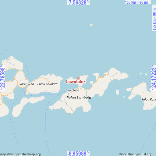
Lewotolok GPS coordinates[2]
8° 15' 52.92" South, 123° 28' 8.76" East
| Map corner | latitude | longitude |
|---|---|---|
| Upper-left | -7.56828°, | 122.76598° |
| Center: | -8.2647°, | 123.4691° |
| Lower-right: | -8.95989°, | 124.17223° |
| Map W x H: | 154.7×154.7 km | = 96.1×96.1mi |
| max Lat: | 5.88969° ⇑75% North |
| Lewotolok: | -8.2647° |
| min Lat: | ⇓25% South -10.934° |
| min Long | Lewotolok | max Long |
| 95.1345° | 123.4691° | 140.9419° |
| W 92.2%⇐ | ⇒7.8% E |
Elevation
Elevation of Lewotolok is 23 m = 75 ft, and this is 206.7 m = 678 ft below average elevation for this country.
| Max E: |
3185 m = 10449 ft | 76.2% |
| Avg. | 229.7 m = 754 ft | |
| Lewotolok | 23 m = 75 ft | |
Min E: |
-1 m = -3 ft | 23.8% |
See also: Indonesia elevation on elevation.city.
Geographical zone
Lewotolok is located in South Torrid zone (between Equator and Tropic of Capricorn). Distance of Equator is 918.9 km =571 mi to North.| Distance of | km | miles | from Lewotolok |
|---|---|---|---|
| Equator | 918.9 | 571 | to North |
| Tropic Capricorn | 1687 | 1048.3 | to South |
| Antarctic Circle | 6482.2 | 4027.9 | to South |
| South Pole | 9088.1 | 5647.1 | to South |


Nearby cities:
15 places around Lewotolok: (largest is in red/bold)
• Atawutung
3.7 km =2.3 mi,  49°
49°
• Baopukang
7.3 km =4.5 mi,  131°
131°
• Dualein
1.1 km =0.7 mi,  233°
233°
• Ebak
6.3 km =3.9 mi,  62°
62°
• Holoriang
7.8 km =4.8 mi,  263°
263°
• Kimakamak
8.5 km =5.3 mi,  155°
155°
• Lewobelen
8.3 km =5.2 mi, 263°
• Mawa
2.8 km =1.7 mi,  42°
42°
• Muruona
7.3 km =4.5 mi,  173°
173°
• Ohe
5.6 km =3.5 mi,  192°
192°
• Riangbao
4.5 km =2.8 mi,  204°
204°
• Tanjungbatu
0.6 km =0.4 mi,  219°
219°
• Tokojaeng
8.6 km =5.3 mi,  85°
85°
• Waipukang
6.3 km =3.9 mi, 185°
• Watomean
1.5 km =0.9 mi,  34°
34°
Sources, notices
• [Note1] Compared only with cities in Indonesia existing in our database
• [Src1] Map data: © OpenStreetMap contributors (CC-BY-SA)
• [Src2] Other city data from geonames.org with taken over terms of usage.
• [Src3] Geographical zone / Annual Mean Temperature by Robert A. Rohde @ Wikipedia
