Kualakapuas geodata
Kualakapuas (Central Kalimantan) is a populated place; located in Indonesia in Asia/Pontianak (GMT+7) time zone. With population of 35,632 people, there are 286 cities with bigger population in this country. Compared to other cities in Indonesia, 91.2% of cities are located further ↓South; 69.7% of cities are located further ←West and 92.1% of cities have higher elevation than Kualakapuas. Note1


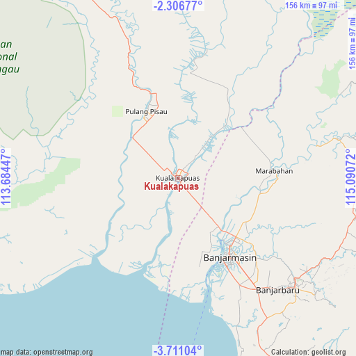
Kualakapuas GPS coordinates[2]
3° 0' 32.868" South, 114° 23' 15.324" East
| Map corner | latitude | longitude |
|---|---|---|
| Upper-left | -2.30677°, | 113.68447° |
| Center: | -3.00913°, | 114.38759° |
| Lower-right: | -3.71104°, | 115.09072° |
| Map W x H: | 156.1×156.1 km | = 97×97mi |
| max Lat: | 5.88969° ⇑8.8% North |
| Kualakapuas: | -3.00913° |
| min Lat: | ⇓91.2% South -10.934° |
| min Long | Kualakapuas | max Long |
| 95.1345° | 114.38759° | 140.9419° |
| W 69.7%⇐ | ⇒30.3% E |
Elevation
Elevation of Kualakapuas is 9 m = 30 ft, and this is 220.7 m = 724 ft below average elevation for this country.
| Max E: |
3185 m = 10449 ft | 92.1% |
| Avg. | 229.7 m = 754 ft | |
| Kualakapuas | 9 m = 30 ft | |
Min E: |
-1 m = -3 ft | 7.9% |
See also: Indonesia elevation on elevation.city.
Geographical zone
Kualakapuas is located in South Torrid zone (between Equator and Tropic of Capricorn). Distance of Equator is 334.6 km =207.9 mi to North.| Distance of | km | miles | from Kualakapuas |
|---|---|---|---|
| Equator | 334.6 | 207.9 | to North |
| Tropic Capricorn | 2271.3 | 1411.3 | to South |
| Antarctic Circle | 7066.6 | 4391 | to South |
| South Pole | 9672.5 | 6010.2 | to South |


Nearby cities:
15 places around Kualakapuas: (largest is in red/bold)
• Anjirmuara
28.9 km =18 mi,  136°
136°
• Anjirserapat
3.3 km =2.1 mi,  185°
185°
• Banjarmasin
41.3 km =25.7 mi,  146°
146°
• Bantul
41.7 km =25.9 mi,  95°
95°
• Barimba
9.7 km =6 mi,  39°
39°
• Basarang
11 km =6.8 mi,  297°
297°
• Belawang
31.1 km =19.3 mi, 102°
• Lupak
43.6 km =27.1 mi,  197°
197°
• Marabahan
42.3 km =26.3 mi,  90°
90°
• Matangai
47.5 km =29.5 mi,  358°
358°
• Pulang Pisau
31.5 km =19.6 mi,  328°
328°
• Sungaigampa
35.7 km =22.2 mi, 103°
• Sungaipuntik
37.3 km =23.2 mi,  118°
118°
• Sungaitatas
22.4 km =13.9 mi,  30°
30°
• Tabunganen
45.8 km =28.5 mi,  166°
166°
Sources, notices
• [Note1] Compared only with cities in Indonesia existing in our database
• [Src1] Map data: © OpenStreetMap contributors (CC-BY-SA)
• [Src2] Other city data from geonames.org with taken over terms of usage.
• [Src3] Geographical zone / Annual Mean Temperature by Robert A. Rohde @ Wikipedia
