Kamal geodata
Kamal (East Java) is a populated place; located in Indonesia in Asia/Jakarta (GMT+7) time zone. With population of 22,515 people, there are 366 cities with bigger population in this country. Compared to other cities in Indonesia, 56.6% of cities are located further ↓South; 57.1% of cities are located further ←West and 95.5% of cities have higher elevation than Kamal. Note1


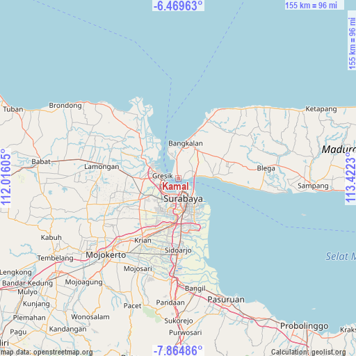
Kamal GPS coordinates[2]
7° 10' 4.008" South, 112° 43' 9.012" East
| Map corner | latitude | longitude |
|---|---|---|
| Upper-left | -6.46963°, | 112.01605° |
| Center: | -7.16778°, | 112.71917° |
| Lower-right: | -7.86486°, | 113.4223° |
| Map W x H: | 155.1×155.1 km | = 96.4×96.4mi |
| max Lat: | 5.88969° ⇑43.4% North |
| Kamal: | -7.16778° |
| min Lat: | ⇓56.6% South -10.934° |
| min Long | Kamal | max Long |
| 95.1345° | 112.71917° | 140.9419° |
| W 57.1%⇐ | ⇒42.9% E |
Elevation
Elevation of Kamal is 7 m = 23 ft, and this is 222.7 m = 731 ft below average elevation for this country.
| Max E: |
3185 m = 10449 ft | 95.5% |
| Avg. | 229.7 m = 754 ft | |
| Kamal | 7 m = 23 ft | |
Min E: |
-1 m = -3 ft | 4.5% |
See also: Indonesia elevation on elevation.city.
Geographical zone
Kamal is located in South Torrid zone (between Equator and Tropic of Capricorn). Distance of Equator is 797 km =495.2 mi to North.| Distance of | km | miles | from Kamal |
|---|---|---|---|
| Equator | 797 | 495.2 | to North |
| Tropic Capricorn | 1808.9 | 1124 | to South |
| Antarctic Circle | 6604.2 | 4103.7 | to South |
| South Pole | 9210.1 | 5722.9 | to South |


Nearby cities:
15 places around Kamal: (largest is in red/bold)
• Bangkalan
13.7 km =8.5 mi,  7°
7°
• Brongkalan
11.3 km =7 mi,  151°
151°
• Gresik
7.1 km =4.4 mi,  282°
282°
• Gubengairlangga
12.4 km =7.7 mi,  160°
160°
• Jagirsidosermo
15.9 km =9.9 mi,  165°
165°
• Kebomas
9.5 km =5.9 mi,  270°
270°
• Labansari
13 km =8.1 mi,  142°
142°
• Mulyorejo
12.8 km =8 mi, 145°
• Pacarkeling
10.9 km =6.8 mi, 156°
• Panjangjiwo
16.9 km =10.5 mi, 162°
• Ploso
10.6 km =6.6 mi, 152°
• Prapen
16.8 km =10.4 mi, 165°
• Semampir
17 km =10.6 mi, 156°
• Surabaya
9.7 km =6 mi, 158°
• Tenggilis Lama
17.2 km =10.7 mi, 163°
Sources, notices
• [Note1] Compared only with cities in Indonesia existing in our database
• [Src1] Map data: © OpenStreetMap contributors (CC-BY-SA)
• [Src2] Other city data from geonames.org with taken over terms of usage.
• [Src3] Geographical zone / Annual Mean Temperature by Robert A. Rohde @ Wikipedia
