Gresik geodata
Gresik (East Java) is a seat of a second-order administrative division; located in Indonesia in Asia/Jakarta (GMT+7) time zone. With population of 73,629 people, there are 173 cities with bigger population in this country. Compared to other cities in Indonesia, 57.5% of cities are located further ↓South; 56.5% of cities are located further ←West and 90.6% of cities have higher elevation than Gresik. Note1


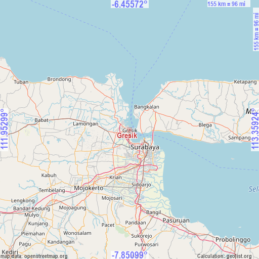
Gresik GPS coordinates[2]
7° 9' 14.004" South, 112° 39' 21.996" East
| Map corner | latitude | longitude |
|---|---|---|
| Upper-left | -6.45572°, | 111.95299° |
| Center: | -7.15389°, | 112.65611° |
| Lower-right: | -7.85099°, | 113.35924° |
| Map W x H: | 155.1×155.1 km | = 96.4×96.4mi |
| max Lat: | 5.88969° ⇑42.5% North |
| Gresik: | -7.15389° |
| min Lat: | ⇓57.5% South -10.934° |
| min Long | Gresik | max Long |
| 95.1345° | 112.65611° | 140.9419° |
| W 56.5%⇐ | ⇒43.5% E |
Elevation
Elevation of Gresik is 10 m = 33 ft, and this is 219.7 m = 721 ft below average elevation for this country.
| Max E: |
3185 m = 10449 ft | 90.6% |
| Avg. | 229.7 m = 754 ft | |
| Gresik | 10 m = 33 ft | |
Min E: |
-1 m = -3 ft | 9.4% |
See also: Gresik elevation on elevation.city.
Geographical zone
Gresik is located in South Torrid zone (between Equator and Tropic of Capricorn). Distance of Equator is 795.4 km =494.2 mi to North.| Distance of | km | miles | from Gresik |
|---|---|---|---|
| Equator | 795.4 | 494.2 | to North |
| Tropic Capricorn | 1810.5 | 1125 | to South |
| Antarctic Circle | 6605.7 | 4104.6 | to South |
| South Pole | 9211.6 | 5723.8 | to South |


Nearby cities:
15 places around Gresik: (largest is in red/bold)
• Asemanis
19.4 km =12.1 mi,  332°
332°
• Bangkalan
14.9 km =9.3 mi,  35°
35°
• Bendungan
17.9 km =11.1 mi,  282°
282°
• Brongkalan
16.8 km =10.4 mi,  133°
133°
• Gubengairlangga
17.3 km =10.7 mi,  139°
139°
• Kamal
7.1 km =4.4 mi,  102°
102°
• Kebomas
2.9 km =1.8 mi,  240°
240°
• Labansari
19 km =11.8 mi, 128°
• Mulyorejo
18.6 km =11.6 mi, 130°
• Pacarkeling
16.1 km =10 mi, 135°
• Ploso
16.1 km =10 mi, 132°
• Plosobuden
18.7 km =11.6 mi,  289°
289°
• Randuboto
18.7 km =11.6 mi, 333°
• Sudangan
19.4 km =12.1 mi, 293°
• Surabaya
14.9 km =9.3 mi, 135°
Sources, notices
• [Note1] Compared only with cities in Indonesia existing in our database
• [Src1] Map data: © OpenStreetMap contributors (CC-BY-SA)
• [Src2] Other city data from geonames.org with taken over terms of usage.
• [Src3] Geographical zone / Annual Mean Temperature by Robert A. Rohde @ Wikipedia
