Jatiwangi geodata
Jatiwangi (West Java) is a populated place; located in Indonesia in Asia/Jakarta (GMT+7) time zone. With population of 57,973 people, there are 206 cities with bigger population in this country. Compared to other cities in Indonesia, 78.9% of cities are located further ↓South; 75.3% of cities are located further →East and 63.5% of cities have higher elevation than Jatiwangi. Note1


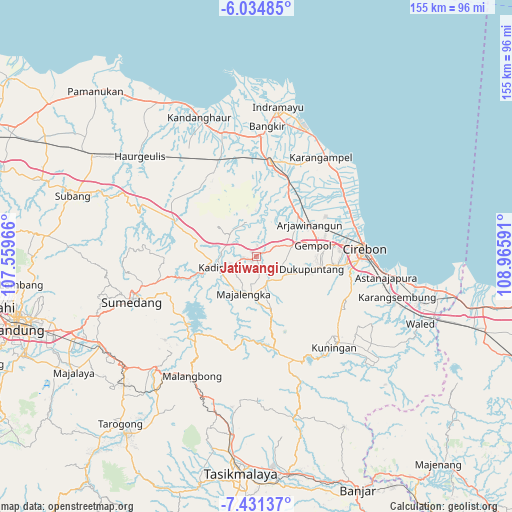
Jatiwangi GPS coordinates[2]
6° 44' 0.996" South, 108° 15' 46.008" East
| Map corner | latitude | longitude |
|---|---|---|
| Upper-left | -6.03485°, | 107.55966° |
| Center: | -6.73361°, | 108.26278° |
| Lower-right: | -7.43137°, | 108.96591° |
| Map W x H: | 155.3×155.3 km | = 96.5×96.5mi |
| max Lat: | 5.88969° ⇑21.1% North |
| Jatiwangi: | -6.73361° |
| min Lat: | ⇓78.9% South -10.934° |
| min Long | Jatiwangi | max Long |
| 95.1345° | 108.26278° | 140.9419° |
| W 24.7%⇐ | ⇒75.3% E |
Elevation
Elevation of Jatiwangi is 47 m = 154 ft, and this is 182.7 m = 599 ft below average elevation for this country.
| Max E: |
3185 m = 10449 ft | 63.5% |
| Avg. | 229.7 m = 754 ft | |
| Jatiwangi | 47 m = 154 ft | |
Min E: |
-1 m = -3 ft | 36.5% |
See also: Jatiwangi elevation on elevation.city.
Geographical zone
Jatiwangi is located in South Torrid zone (between Equator and Tropic of Capricorn). Distance of Equator is 748.7 km =465.2 mi to North.| Distance of | km | miles | from Jatiwangi |
|---|---|---|---|
| Equator | 748.7 | 465.2 | to North |
| Tropic Capricorn | 1857.2 | 1154 | to South |
| Antarctic Circle | 6652.5 | 4133.7 | to South |
| South Pole | 9258.4 | 5752.9 | to South |


Nearby cities:
15 places around Jatiwangi: (largest is in red/bold)
• Arjawinangun
19 km =11.8 mi,  58°
58°
• Cimanggu Hilir
30.1 km =18.7 mi,  180°
180°
• Cintasari
31.5 km =19.6 mi,  162°
162°
• Cipeundeuy
31.4 km =19.5 mi,  186°
186°
• Dalamdesa Kalapadua
30.3 km =18.8 mi, 187°
• Jatibarang
29.4 km =18.3 mi,  11°
11°
• Jatipamor
30.8 km =19.1 mi,  166°
166°
• Klangenan
19.8 km =12.3 mi,  82°
82°
• Majalengka
12 km =7.5 mi,  198°
198°
• Margamukti
30.7 km =19.1 mi, 175°
• Palimanan
18.1 km =11.2 mi, 80°
• Plumbon
23.4 km =14.5 mi, 82°
• Sindang
31.2 km =19.4 mi, 165°
• Sumber
24.5 km =15.2 mi,  96°
96°
• Weru
26.7 km =16.6 mi, 84°
Sources, notices
• [Note1] Compared only with cities in Indonesia existing in our database
• [Src1] Map data: © OpenStreetMap contributors (CC-BY-SA)
• [Src2] Other city data from geonames.org with taken over terms of usage.
• [Src3] Geographical zone / Annual Mean Temperature by Robert A. Rohde @ Wikipedia
