Weru geodata
Weru (West Java) is a populated place; located in Indonesia in Asia/Jakarta (GMT+7) time zone. With population of 139,004 people, there are 86 cities with bigger population in this country. Compared to other cities in Indonesia, 80% of cities are located further ↓South; 71.5% of cities are located further →East and 79.9% of cities have higher elevation than Weru. Note1


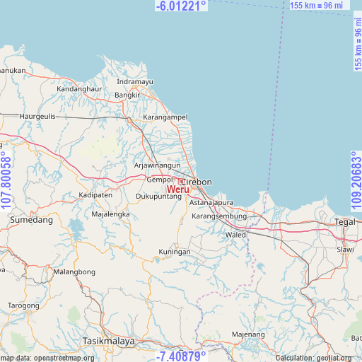
Weru GPS coordinates[2]
6° 42' 39.6" South, 108° 30' 13.32" East
| Map corner | latitude | longitude |
|---|---|---|
| Upper-left | -6.01221°, | 107.80058° |
| Center: | -6.711°, | 108.5037° |
| Lower-right: | -7.40879°, | 109.20683° |
| Map W x H: | 155.3×155.3 km | = 96.5×96.5mi |
| max Lat: | 5.88969° ⇑20% North |
| Weru: | -6.711° |
| min Lat: | ⇓80% South -10.934° |
| min Long | Weru | max Long |
| 95.1345° | 108.5037° | 140.9419° |
| W 28.5%⇐ | ⇒71.5% E |
Elevation
Elevation of Weru is 19 m = 62 ft, and this is 210.7 m = 691 ft below average elevation for this country.
| Max E: |
3185 m = 10449 ft | 79.9% |
| Avg. | 229.7 m = 754 ft | |
| Weru | 19 m = 62 ft | |
Min E: |
-1 m = -3 ft | 20.1% |
See also: Weru elevation on elevation.city.
Geographical zone
Weru is located in South Torrid zone (between Equator and Tropic of Capricorn). Distance of Equator is 746.2 km =463.7 mi to North.| Distance of | km | miles | from Weru |
|---|---|---|---|
| Equator | 746.2 | 463.7 | to North |
| Tropic Capricorn | 1859.7 | 1155.6 | to South |
| Antarctic Circle | 6655 | 4135.2 | to South |
| South Pole | 9260.9 | 5754.5 | to South |


Nearby cities:
15 places around Weru: (largest is in red/bold)
• Arjawinangun
12.6 km =7.8 mi,  305°
305°
• Astanajapura
17.3 km =10.7 mi,  125°
125°
• Babatan
32.8 km =20.4 mi,  189°
189°
• Cirebon
5.9 km =3.7 mi,  84°
84°
• Garawangi
32.2 km =20 mi,  173°
173°
• Jatiwangi
26.7 km =16.6 mi,  264°
264°
• Karangampel
28.2 km =17.5 mi,  348°
348°
• Karangsembung
21.6 km =13.4 mi,  135°
135°
• Klangenan
7 km =4.3 mi,  271°
271°
• Kuningan
29.5 km =18.3 mi,  184°
184°
• Olejet
32.1 km =19.9 mi, 166°
• Palimanan
8.8 km =5.5 mi, 272°
• Plumbon
3.5 km =2.2 mi,  281°
281°
• Sumber
5.9 km =3.7 mi,  202°
202°
• Tembong
32.6 km =20.3 mi, 178°
Sources, notices
• [Note1] Compared only with cities in Indonesia existing in our database
• [Src1] Map data: © OpenStreetMap contributors (CC-BY-SA)
• [Src2] Other city data from geonames.org with taken over terms of usage.
• [Src3] Geographical zone / Annual Mean Temperature by Robert A. Rohde @ Wikipedia
