Gunungbitung geodata
Gunungbitung (West Java) is a seat of a fourth-order administrative division; located in Indonesia in Asia/Jakarta (GMT+7) time zone. In our database, there are 407 cities with bigger population. Compared to other cities in Indonesia, 50.4% of cities are located further ↓South; 85% of cities are located further →East and 83.5% of cities have lower elevation than Gunungbitung. Note1


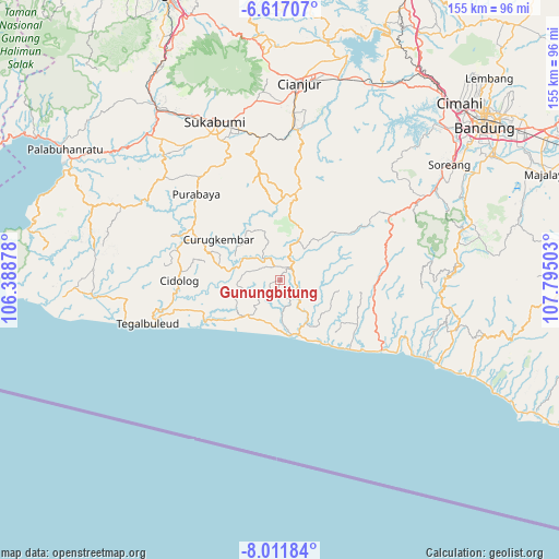
Gunungbitung GPS coordinates[2]
7° 18' 54" South, 107° 5' 30.84" East
| Map corner | latitude | longitude |
|---|---|---|
| Upper-left | -6.61707°, | 106.38878° |
| Center: | -7.315°, | 107.0919° |
| Lower-right: | -8.01184°, | 107.79503° |
| Map W x H: | 155.1×155.1 km | = 96.4×96.4mi |
| max Lat: | 5.88969° ⇑49.6% North |
| Gunungbitung: | -7.315° |
| min Lat: | ⇓50.4% South -10.934° |
| min Long | Gunungbitung | max Long |
| 95.1345° | 107.0919° | 140.9419° |
| W 15%⇐ | ⇒85% E |
Elevation
Elevation of Gunungbitung is 489 m = 1604 ft, and this is 259.3 m = 851 ft above average elevation for this country.
| Max E: |
3185 m = 10449 ft | 16.5% |
| Gunungbitung | 489 m 1604 ft | |
| Avg. | 229.7 m = 754 ft | |
Min E: |
-1 m = -3 ft | 83.5% |
See also: Indonesia elevation on elevation.city.
Geographical zone
Gunungbitung is located in South Torrid zone (between Equator and Tropic of Capricorn). Distance of Equator is 813.4 km =505.4 mi to North.| Distance of | km | miles | from Gunungbitung |
|---|---|---|---|
| Equator | 813.4 | 505.4 | to North |
| Tropic Capricorn | 1792.6 | 1113.9 | to South |
| Antarctic Circle | 6587.8 | 4093.5 | to South |
| South Pole | 9193.7 | 5712.7 | to South |


Nearby cities:
15 places around Gunungbitung: (largest is in red/bold)
• Ankola
4 km =2.5 mi,  77°
77°
• Babakantugu
6.3 km =3.9 mi,  353°
353°
• Cibinong Satu
4 km =2.5 mi,  102°
102°
• Cihamerang
4.9 km =3 mi,  216°
216°
• Cimanggu
1.9 km =1.2 mi,  89°
89°
• Gelarmukti
3.7 km =2.3 mi, 221°
• Pasirmanggu
5.5 km =3.4 mi,  18°
18°
• Puncakwangi
3.5 km =2.2 mi,  306°
306°
• Rawawilis
3.8 km =2.4 mi,  358°
358°
• Sinarwangi
4.3 km =2.7 mi, 21°
• Sumur
3.8 km =2.4 mi, 347°
• Tanggeung
6.3 km =3.9 mi,  33°
33°
• Tanggeung Kolot
6.3 km =3.9 mi,  46°
46°
• Tegalheras
4.9 km =3 mi,  324°
324°
• Tegalpanjang
7.1 km =4.4 mi, 48°
Sources, notices
• [Note1] Compared only with cities in Indonesia existing in our database
• [Src1] Map data: © OpenStreetMap contributors (CC-BY-SA)
• [Src2] Other city data from geonames.org with taken over terms of usage.
• [Src3] Geographical zone / Annual Mean Temperature by Robert A. Rohde @ Wikipedia
