Enok geodata
Enok (Riau) is a seat of a third-order administrative division; located in Indonesia in Asia/Jakarta (GMT+7) time zone. In our database, there are 407 cities with bigger population. Compared to other cities in Indonesia, 94.6% of cities are located further ↓South; 95.6% of cities are located further →East and 99.7% of cities have higher elevation than Enok. Note1


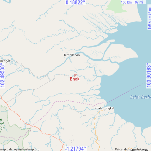
Enok GPS coordinates[2]
0° 30' 53.64" South, 103° 11' 54.6" East
| Map corner | latitude | longitude |
|---|---|---|
| Upper-left | 0.18822°, | 102.49538° |
| Center: | -0.5149°, | 103.1985° |
| Lower-right: | -1.21794°, | 103.90163° |
| Map W x H: | 156.4×156.4 km | = 97.2×97.2mi |
| max Lat: | 5.88969° ⇑5.4% North |
| Enok: | -0.5149° |
| min Lat: | ⇓94.6% South -10.934° |
| min Long | Enok | max Long |
| 95.1345° | 103.1985° | 140.9419° |
| W 4.4%⇐ | ⇒95.6% E |
Elevation
Elevation of Enok is 2 m = 7 ft, and this is 227.7 m = 747 ft below average elevation for this country.
| Max E: |
3185 m = 10449 ft | 99.7% |
| Avg. | 229.7 m = 754 ft | |
| Enok | 2 m = 7 ft | |
Min E: |
-1 m = -3 ft | 0.3% |
See also: Indonesia elevation on elevation.city.
Geographical zone
Enok is located in South Torrid zone (between Equator and Tropic of Capricorn). Distance of Equator is 57.3 km =35.6 mi to North.| Distance of | km | miles | from Enok |
|---|---|---|---|
| Equator | 57.3 | 35.6 | to North |
| Tropic Capricorn | 2548.7 | 1583.7 | to South |
| Antarctic Circle | 7343.9 | 4563.3 | to South |
| South Pole | 9949.8 | 6182.5 | to South |


Nearby cities:
15 places around Enok: (largest is in red/bold)
• Airmolek
102 km =63.4 mi,  279°
279°
• Khairiahmandah
68.2 km =42.4 mi,  29°
29°
• Kuala Tungkal
44.4 km =27.6 mi,  138°
138°
• Mendaha
71 km =44.1 mi, 141°
• Muara Sabak
100.1 km =62.2 mi,  133°
133°
• Pangkalan Kasai
90.3 km =56.1 mi,  264°
264°
• Pelabuhan Dagang
71.3 km =44.3 mi,  190°
190°
• Pulaukijang
19.2 km =11.9 mi,  184°
184°
• Rengat
74 km =46 mi, 282°
• Sapat
24.6 km =15.3 mi, 30°
• Sengeti
112.4 km =69.8 mi,  162°
162°
• Sungaisalak
22.9 km =14.2 mi,  291°
291°
• Teluk Pinang
41.1 km =25.5 mi, 25°
• Telukdalam
116.7 km =72.5 mi,  3°
3°
• Tembilahan
21.8 km =13.5 mi,  348°
348°
Sources, notices
• [Note1] Compared only with cities in Indonesia existing in our database
• [Src1] Map data: © OpenStreetMap contributors (CC-BY-SA)
• [Src2] Other city data from geonames.org with taken over terms of usage.
• [Src3] Geographical zone / Annual Mean Temperature by Robert A. Rohde @ Wikipedia
