Mendaha geodata
Mendaha (Jambi) is a populated place; located in Indonesia in Asia/Jakarta (GMT+7) time zone. With population of 56,268 people, there are 213 cities with bigger population in this country. Compared to other cities in Indonesia, 93.9% of cities are located further ↓South; 95.4% of cities are located further →East and 98.5% of cities have higher elevation than Mendaha. Note1


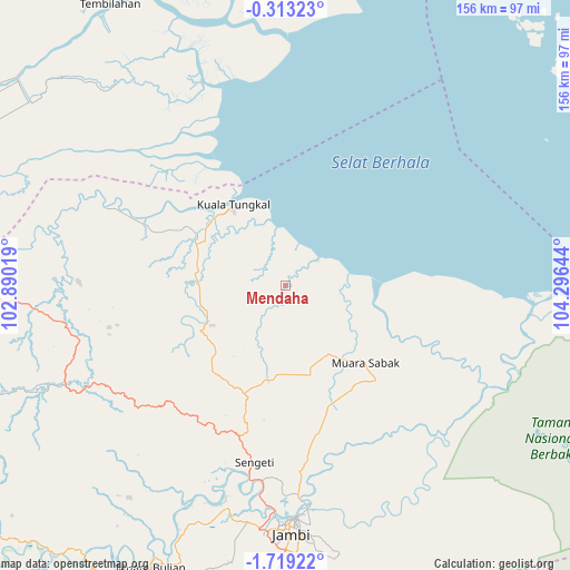
Mendaha GPS coordinates[2]
1° 0' 58.68" South, 103° 35' 35.916" East
| Map corner | latitude | longitude |
|---|---|---|
| Upper-left | -0.31323°, | 102.89019° |
| Center: | -1.0163°, | 103.59331° |
| Lower-right: | -1.71922°, | 104.29644° |
| Map W x H: | 156.3×156.3 km | = 97.1×97.1mi |
| max Lat: | 5.88969° ⇑6.1% North |
| Mendaha: | -1.0163° |
| min Lat: | ⇓93.9% South -10.934° |
| min Long | Mendaha | max Long |
| 95.1345° | 103.59331° | 140.9419° |
| W 4.6%⇐ | ⇒95.4% E |
Elevation
Elevation of Mendaha is 5 m = 16 ft, and this is 224.7 m = 737 ft below average elevation for this country.
| Max E: |
3185 m = 10449 ft | 98.5% |
| Avg. | 229.7 m = 754 ft | |
| Mendaha | 5 m = 16 ft | |
Min E: |
-1 m = -3 ft | 1.5% |
See also: Mendaha elevation on elevation.city.
Geographical zone
Mendaha is located in South Torrid zone (between Equator and Tropic of Capricorn). Distance of Equator is 113 km =70.2 mi to North.| Distance of | km | miles | from Mendaha |
|---|---|---|---|
| Equator | 113 | 70.2 | to North |
| Tropic Capricorn | 2492.9 | 1549 | to South |
| Antarctic Circle | 7288.2 | 4528.7 | to South |
| South Pole | 9894.1 | 6147.9 | to South |


Nearby cities:
15 places around Mendaha: (largest is in red/bold)
• Enok
71 km =44.1 mi,  321°
321°
• Jambi City
65 km =40.4 mi,  177°
177°
• Kenali Asam
72.1 km =44.8 mi, 177°
• Kuala Tungkal
26.7 km =16.6 mi,  326°
326°
• Muara Bulian
85.9 km =53.4 mi,  205°
205°
• Muara Sabak
31.5 km =19.6 mi,  115°
115°
• Nipah Panjang
67.1 km =41.7 mi,  95°
95°
• Pelabuhan Dagang
58.3 km =36.2 mi,  255°
255°
• Pulaukijang
58.4 km =36.3 mi,  308°
308°
• Sapat
83.2 km =51.7 mi,  337°
337°
• Sekernan
56.5 km =35.1 mi, 182°
• Sengeti
52.1 km =32.4 mi,  190°
190°
• Simpang
62.4 km =38.8 mi, 116°
• Sungaisalak
91.5 km =56.9 mi, 314°
• Tembilahan
90.9 km =56.5 mi, 328°
Sources, notices
• [Note1] Compared only with cities in Indonesia existing in our database
• [Src1] Map data: © OpenStreetMap contributors (CC-BY-SA)
• [Src2] Other city data from geonames.org with taken over terms of usage.
• [Src3] Geographical zone / Annual Mean Temperature by Robert A. Rohde @ Wikipedia
