Kuala Tungkal geodata
Kuala Tungkal (Jambi) is a seat of a second-order administrative division; located in Indonesia in Asia/Jakarta (GMT+7) time zone. With population of 33,683 people, there are 295 cities with bigger population in this country. Compared to other cities in Indonesia, 94.1% of cities are located further ↓South; 95.4% of cities are located further →East and 97.2% of cities have higher elevation than Kuala Tungkal. Note1


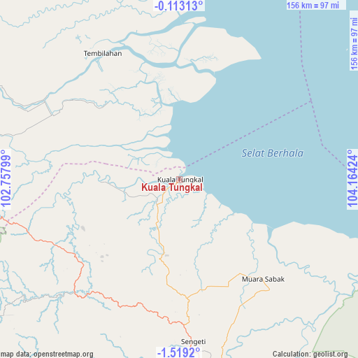
Kuala Tungkal GPS coordinates[2]
0° 48' 58.428" South, 103° 27' 39.996" East
| Map corner | latitude | longitude |
|---|---|---|
| Upper-left | -0.11313°, | 102.75799° |
| Center: | -0.81623°, | 103.46111° |
| Lower-right: | -1.5192°, | 104.16424° |
| Map W x H: | 156.3×156.3 km | = 97.1×97.1mi |
| max Lat: | 5.88969° ⇑5.9% North |
| Kuala Tungkal: | -0.81623° |
| min Lat: | ⇓94.1% South -10.934° |
| min Long | Kuala Tungkal | max Long |
| 95.1345° | 103.46111° | 140.9419° |
| W 4.6%⇐ | ⇒95.4% E |
Elevation
Elevation of Kuala Tungkal is 6 m = 20 ft, and this is 223.7 m = 734 ft below average elevation for this country.
| Max E: |
3185 m = 10449 ft | 97.2% |
| Avg. | 229.7 m = 754 ft | |
| Kuala Tungkal | 6 m = 20 ft | |
Min E: |
-1 m = -3 ft | 2.8% |
See also: Indonesia elevation on elevation.city.
Geographical zone
Kuala Tungkal is located in South Torrid zone (between Equator and Tropic of Capricorn). Distance of Equator is 90.8 km =56.4 mi to North.| Distance of | km | miles | from Kuala Tungkal |
|---|---|---|---|
| Equator | 90.8 | 56.4 | to North |
| Tropic Capricorn | 2515.2 | 1562.9 | to South |
| Antarctic Circle | 7310.4 | 4542.5 | to South |
| South Pole | 9916.3 | 6161.7 | to South |


Nearby cities:
15 places around Kuala Tungkal: (largest is in red/bold)
• Enok
44.4 km =27.6 mi,  318°
318°
• Jambi City
88.8 km =55.2 mi,  168°
168°
• Khairiahmandah
93.2 km =57.9 mi,  2°
2°
• Mendaha
26.7 km =16.6 mi,  146°
146°
• Muara Sabak
56 km =34.8 mi,  129°
129°
• Nipah Panjang
86.5 km =53.7 mi,  109°
109°
• Pelabuhan Dagang
55.6 km =34.5 mi,  228°
228°
• Pulaukijang
34 km =21.1 mi,  295°
295°
• Sapat
57.3 km =35.6 mi,  342°
342°
• Sekernan
79.5 km =49.4 mi, 171°
• Sengeti
73.7 km =45.8 mi,  175°
175°
• Simpang
86.5 km =53.7 mi, 125°
• Sungaisalak
65.7 km =40.8 mi,  309°
309°
• Teluk Pinang
71.4 km =44.4 mi,  350°
350°
• Tembilahan
64.3 km =40 mi,  328°
328°
Sources, notices
• [Note1] Compared only with cities in Indonesia existing in our database
• [Src1] Map data: © OpenStreetMap contributors (CC-BY-SA)
• [Src2] Other city data from geonames.org with taken over terms of usage.
• [Src3] Geographical zone / Annual Mean Temperature by Robert A. Rohde @ Wikipedia
