Dumai geodata
Dumai (Riau) is a populated place; located in Indonesia in Asia/Jakarta (GMT+7) time zone. With population of 143,760 people, there are 82 cities with bigger population in this country. Compared to other cities in Indonesia, 96.8% of cities are located further ↓South; 96.3% of cities are located further →East and 95.5% of cities have higher elevation than Dumai. Note1


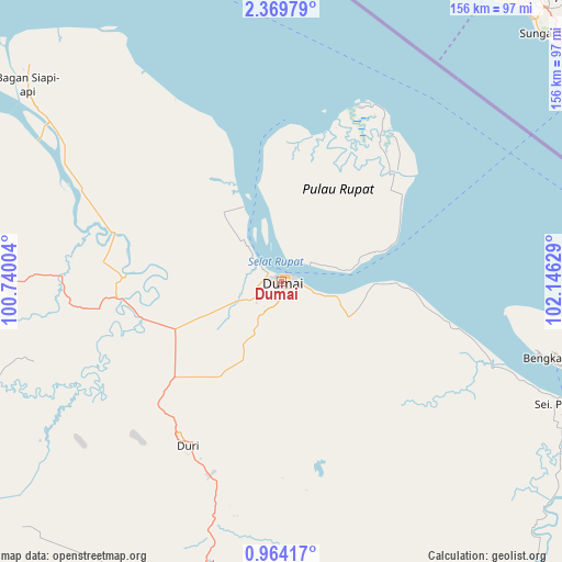
Dumai GPS coordinates[2]
1° 40' 1.596" North, 101° 26' 35.376" East
| Map corner | latitude | longitude |
|---|---|---|
| Upper-left | 2.36979°, | 100.74004° |
| Center: | 1.66711°, | 101.44316° |
| Lower-right: | 0.96417°, | 102.14629° |
| Map W x H: | 156.3×156.3 km | = 97.1×97.1mi |
| max Lat: | 5.88969° ⇑3.2% North |
| Dumai: | 1.66711° |
| min Lat: | ⇓96.8% South -10.934° |
| min Long | Dumai | max Long |
| 95.1345° | 101.44316° | 140.9419° |
| W 3.7%⇐ | ⇒96.3% E |
Elevation
Elevation of Dumai is 7 m = 23 ft, and this is 222.7 m = 731 ft below average elevation for this country.
| Max E: |
3185 m = 10449 ft | 95.5% |
| Avg. | 229.7 m = 754 ft | |
| Dumai | 7 m = 23 ft | |
Min E: |
-1 m = -3 ft | 4.5% |
See also: Dumai elevation on elevation.city.
Geographical zone
Dumai is located in North Torrid zone (between Equator and Tropic of Cancer). Distance of Equator is 185.4 km =115.2 mi to South.| Distance of | km | miles | from Dumai |
|---|---|---|---|
| North Pole | 9821.7 | 6102.9 | to North |
| Arctic Circle | 7215.8 | 4483.7 | to North |
| Tropic Cancer | 2420.6 | 1504.1 | to North |
| Equator | 185.4 | 115.2 | to South |


Nearby cities:
15 places around Dumai: (largest is in red/bold)
• Bagan Besar
11.4 km =7.1 mi,  213°
213°
• Balaipungut
69.7 km =43.3 mi,  194°
194°
• Bangsal Aceh
10.4 km =6.5 mi,  314°
314°
• Batu Panjang
9.4 km =5.8 mi,  57°
57°
• Buluh Kasap
2.1 km =1.3 mi,  43°
43°
• Duri
51.5 km =32 mi, 212°
• Kador
50.3 km =31.3 mi,  34°
34°
• Kampung Laksamana
1.4 km =0.9 mi,  340°
340°
• Labuhantanggabesar
73.9 km =45.9 mi,  303°
303°
• Pajak
53.7 km =33.4 mi,  24°
24°
• Rimba Sekampung
1.1 km =0.7 mi,  326°
326°
• Sedinginan
49.2 km =30.6 mi,  255°
255°
• Tanjung Palas
3.3 km =2.1 mi,  67°
67°
• Teluk Binjai
0.9 km =0.6 mi,  53°
53°
• Titiakar
43.3 km =26.9 mi, 20°
Sources, notices
• [Note1] Compared only with cities in Indonesia existing in our database
• [Src1] Map data: © OpenStreetMap contributors (CC-BY-SA)
• [Src2] Other city data from geonames.org with taken over terms of usage.
• [Src3] Geographical zone / Annual Mean Temperature by Robert A. Rohde @ Wikipedia
