Duri geodata
Duri (Riau) is a seat of a third-order administrative division; located in Indonesia in Asia/Jakarta (GMT+7) time zone. In our database, there are 407 cities with bigger population. Compared to other cities in Indonesia, 96.5% of cities are located further ↓South; 96.5% of cities are located further →East and 61.6% of cities have higher elevation than Duri. Note1


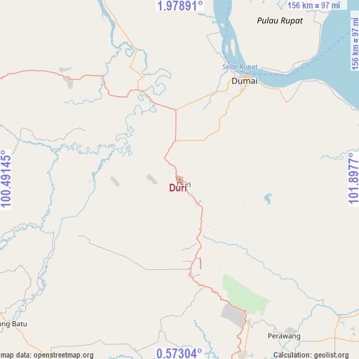
Duri GPS coordinates[2]
1° 16' 33.852" North, 101° 11' 40.452" East
| Map corner | latitude | longitude |
|---|---|---|
| Upper-left | 1.97891°, | 100.49145° |
| Center: | 1.27607°, | 101.19457° |
| Lower-right: | 0.57304°, | 101.8977° |
| Map W x H: | 156.3×156.3 km | = 97.1×97.1mi |
| max Lat: | 5.88969° ⇑3.5% North |
| Duri: | 1.27607° |
| min Lat: | ⇓96.5% South -10.934° |
| min Long | Duri | max Long |
| 95.1345° | 101.19457° | 140.9419° |
| W 3.5%⇐ | ⇒96.5% E |
Elevation
Elevation of Duri is 53 m = 174 ft, and this is 176.7 m = 580 ft below average elevation for this country.
| Max E: |
3185 m = 10449 ft | 61.6% |
| Avg. | 229.7 m = 754 ft | |
| Duri | 53 m = 174 ft | |
Min E: |
-1 m = -3 ft | 38.4% |
See also: Indonesia elevation on elevation.city.
Geographical zone
Duri is located in North Torrid zone (between Equator and Tropic of Cancer). Distance of Equator is 141.9 km =88.2 mi to South.| Distance of | km | miles | from Duri |
|---|---|---|---|
| North Pole | 9865.2 | 6129.9 | to North |
| Arctic Circle | 7259.3 | 4510.7 | to North |
| Tropic Cancer | 2464 | 1531.1 | to North |
| Equator | 141.9 | 88.2 | to South |


Nearby cities:
15 places around Duri: (largest is in red/bold)
• Bagan Besar
40.1 km =24.9 mi,  32°
32°
• Balaipungut
26.3 km =16.3 mi,  156°
156°
• Bangsal Aceh
54.6 km =33.9 mi,  21°
21°
• Batu Panjang
60.1 km =37.3 mi,  36°
36°
• Buluh Kasap
53.6 km =33.3 mi, 32°
• Dumai
51.5 km =32 mi, 32°
• Kampung Laksamana
52.4 km =32.6 mi, 31°
• Kotatengah
74.2 km =46.1 mi,  253°
253°
• Labuhantanggabesar
90.8 km =56.4 mi,  337°
337°
• Pekanbaru
88.8 km =55.2 mi, 161°
• Rimba Sekampung
52 km =32.3 mi, 31°
• Sedinginan
36.8 km =22.9 mi,  327°
327°
• Tanjung Palas
54.2 km =33.7 mi, 34°
• Teluk Binjai
52.4 km =32.6 mi, 32°
• Titiakar
94.3 km =58.6 mi, 27°
Sources, notices
• [Note1] Compared only with cities in Indonesia existing in our database
• [Src1] Map data: © OpenStreetMap contributors (CC-BY-SA)
• [Src2] Other city data from geonames.org with taken over terms of usage.
• [Src3] Geographical zone / Annual Mean Temperature by Robert A. Rohde @ Wikipedia
