Balaipungut geodata
Balaipungut (Riau) is a populated place; located in Indonesia in Asia/Jakarta (GMT+7) time zone. With population of 56,452 people, there are 212 cities with bigger population in this country. Compared to other cities in Indonesia, 96.3% of cities are located further ↓South; 96.4% of cities are located further →East and 83% of cities have higher elevation than Balaipungut. Note1


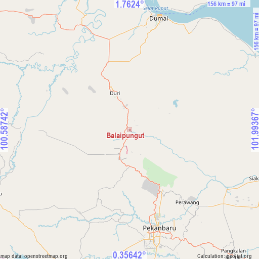
Balaipungut GPS coordinates[2]
1° 3' 34.164" North, 101° 17' 25.944" East
| Map corner | latitude | longitude |
|---|---|---|
| Upper-left | 1.7624°, | 100.58742° |
| Center: | 1.05949°, | 101.29054° |
| Lower-right: | 0.35642°, | 101.99367° |
| Map W x H: | 156.3×156.3 km | = 97.1×97.1mi |
| max Lat: | 5.88969° ⇑3.7% North |
| Balaipungut: | 1.05949° |
| min Lat: | ⇓96.3% South -10.934° |
| min Long | Balaipungut | max Long |
| 95.1345° | 101.29054° | 140.9419° |
| W 3.6%⇐ | ⇒96.4% E |
Elevation
Elevation of Balaipungut is 16 m = 52 ft, and this is 213.7 m = 701 ft below average elevation for this country.
| Max E: |
3185 m = 10449 ft | 83% |
| Avg. | 229.7 m = 754 ft | |
| Balaipungut | 16 m = 52 ft | |
Min E: |
-1 m = -3 ft | 17% |
See also: Balaipungut elevation on elevation.city.
Geographical zone
Balaipungut is located in North Torrid zone (between Equator and Tropic of Cancer). Distance of Equator is 117.8 km =73.2 mi to South.| Distance of | km | miles | from Balaipungut |
|---|---|---|---|
| North Pole | 9889.3 | 6144.9 | to North |
| Arctic Circle | 7283.4 | 4525.7 | to North |
| Tropic Cancer | 2488.1 | 1546 | to North |
| Equator | 117.8 | 73.2 | to South |


Nearby cities:
15 places around Balaipungut: (largest is in red/bold)
• Bagan Besar
59.1 km =36.7 mi,  10°
10°
• Bangkinang
85.5 km =53.1 mi,  200°
200°
• Bangsal Aceh
75.4 km =46.9 mi, 7°
• Batu Panjang
76.7 km =47.7 mi,  18°
18°
• Buluh Kasap
71.5 km =44.4 mi, 14°
• Dumai
69.7 km =43.3 mi, 14°
• Duri
26.3 km =16.3 mi,  336°
336°
• Kampung Laksamana
70.9 km =44.1 mi, 13°
• Kotatengah
81.9 km =50.9 mi,  272°
272°
• Pekanbaru
62.7 km =39 mi,  164°
164°
• Rimba Sekampung
70.4 km =43.7 mi, 13°
• Sedinginan
62.9 km =39.1 mi,  330°
330°
• Siak Sri Indrapura
89.6 km =55.7 mi,  109°
109°
• Tanjung Palas
71.7 km =44.6 mi, 16°
• Teluk Binjai
70.4 km =43.7 mi, 14°
Sources, notices
• [Note1] Compared only with cities in Indonesia existing in our database
• [Src1] Map data: © OpenStreetMap contributors (CC-BY-SA)
• [Src2] Other city data from geonames.org with taken over terms of usage.
• [Src3] Geographical zone / Annual Mean Temperature by Robert A. Rohde @ Wikipedia
