Banjar geodata
Banjar (West Java) is a populated place; located in Indonesia in Asia/Jakarta (GMT+7) time zone. With population of 37,263 people, there are 281 cities with bigger population in this country. Compared to other cities in Indonesia, 55.3% of cities are located further ↓South; 84.2% of cities are located further →East and 99.9% of cities have lower elevation than Banjar. Note1


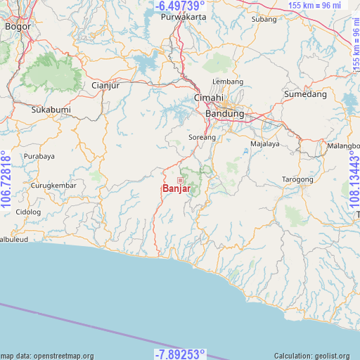
Banjar GPS coordinates[2]
7° 11' 43.8" South, 107° 25' 52.68" East
| Map corner | latitude | longitude |
|---|---|---|
| Upper-left | -6.49739°, | 106.72818° |
| Center: | -7.1955°, | 107.4313° |
| Lower-right: | -7.89253°, | 108.13443° |
| Map W x H: | 155.1×155.1 km | = 96.4×96.4mi |
| max Lat: | 5.88969° ⇑44.7% North |
| Banjar: | -7.1955° |
| min Lat: | ⇓55.3% South -10.934° |
| min Long | Banjar | max Long |
| 95.1345° | 107.4313° | 140.9419° |
| W 15.8%⇐ | ⇒84.2% E |
Elevation
Elevation of Banjar is 1874 m = 6148 ft, and this is 1644.3 m = 5395 ft above average elevation for this country.
| Max E: |
3185 m = 10449 ft | 0.099999999999994% |
| Banjar | 1874 m 6148 ft | |
| Avg. | 229.7 m = 754 ft | |
Min E: |
-1 m = -3 ft | 99.9% |
See also: Indonesia elevation on elevation.city.
Geographical zone
Banjar is located in South Torrid zone (between Equator and Tropic of Capricorn). Distance of Equator is 800.1 km =497.2 mi to North.| Distance of | km | miles | from Banjar |
|---|---|---|---|
| Equator | 800.1 | 497.2 | to North |
| Tropic Capricorn | 1805.9 | 1122.1 | to South |
| Antarctic Circle | 6601.1 | 4101.7 | to South |
| South Pole | 9207 | 5721 | to South |


Nearby cities:
15 places around Banjar: (largest is in red/bold)
• Balegede
11.2 km =7 mi,  227°
227°
• Cibuluh
18.9 km =11.7 mi,  171°
171°
• Cibungur
15.4 km =9.6 mi,  133°
133°
• Cihaur
16.6 km =10.3 mi,  139°
139°
• Genteng
13.5 km =8.4 mi,  148°
148°
• Mancagahar
16.7 km =10.4 mi, 152°
• Mekarjaya
12 km =7.5 mi, 171°
• Mitrabakti
12.8 km =8 mi,  218°
218°
• Naringgul
19.2 km =11.9 mi, 216°
• Pancalan
18.6 km =11.6 mi, 224°
• Pasirangin Satu
16 km =9.9 mi, 126°
• Puncakbaru
15.6 km =9.7 mi, 173°
• Sawahlegok
11 km =6.8 mi,  160°
160°
• Selaawi
14.7 km =9.1 mi, 159°
• Talegong Dua
14.6 km =9.1 mi, 142°
Sources, notices
• [Note1] Compared only with cities in Indonesia existing in our database
• [Src1] Map data: © OpenStreetMap contributors (CC-BY-SA)
• [Src2] Other city data from geonames.org with taken over terms of usage.
• [Src3] Geographical zone / Annual Mean Temperature by Robert A. Rohde @ Wikipedia
