Malabar geodata
Malabar (Central Java) is a seat of a fourth-order administrative division; located in Indonesia in Asia/Jakarta (GMT+7) time zone. In our database, there are 407 cities with bigger population. Compared to other cities in Indonesia, 51% of cities are located further ↓South; 69% of cities are located further →East and 61.9% of cities have lower elevation than Malabar. Note1


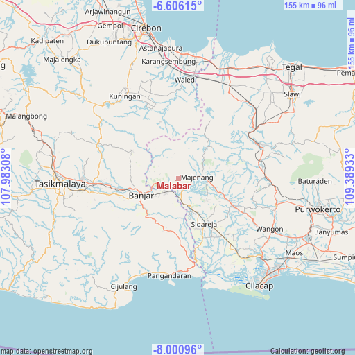
Malabar GPS coordinates[2]
7° 18' 14.76" South, 108° 41' 10.32" East
| Map corner | latitude | longitude |
|---|---|---|
| Upper-left | -6.60615°, | 107.98308° |
| Center: | -7.3041°, | 108.6862° |
| Lower-right: | -8.00096°, | 109.38933° |
| Map W x H: | 155.1×155.1 km | = 96.4×96.4mi |
| max Lat: | 5.88969° ⇑49% North |
| Malabar: | -7.3041° |
| min Lat: | ⇓51% South -10.934° |
| min Long | Malabar | max Long |
| 95.1345° | 108.6862° | 140.9419° |
| W 31%⇐ | ⇒69% E |
Elevation
Elevation of Malabar is 184 m = 604 ft, and this is 45.7 m = 150 ft below average elevation for this country.
| Max E: |
3185 m = 10449 ft | 38.1% |
| Avg. | 229.7 m = 754 ft | |
| Malabar | 184 m = 604 ft | |
Min E: |
-1 m = -3 ft | 61.9% |
See also: Indonesia elevation on elevation.city.
Geographical zone
Malabar is located in South Torrid zone (between Equator and Tropic of Capricorn). Distance of Equator is 812.1 km =504.6 mi to North.| Distance of | km | miles | from Malabar |
|---|---|---|---|
| Equator | 812.1 | 504.6 | to North |
| Tropic Capricorn | 1793.8 | 1114.6 | to South |
| Antarctic Circle | 6589 | 4094.2 | to South |
| South Pole | 9194.9 | 5713.4 | to South |


Nearby cities:
15 places around Malabar: (largest is in red/bold)
• Bakung
5.5 km =3.4 mi,  191°
191°
• Cibeunying
6.5 km =4 mi,  79°
79°
• Cihandiwung Lor
3.3 km =2.1 mi,  173°
173°
• Cimalati
4.3 km =2.7 mi,  267°
267°
• Cintaratu
7.5 km =4.7 mi, 186°
• Karanganyar
5.5 km =3.4 mi,  236°
236°
• Karanggedang
4.3 km =2.7 mi,  86°
86°
• Kubang
6.3 km =3.9 mi,  302°
302°
• Limbangan
2.7 km =1.7 mi, 86°
• Majingklak
1.2 km =0.7 mi,  264°
264°
• Mulyadadi
7.4 km =4.6 mi,  104°
104°
• Pahonjean
6.2 km =3.9 mi,  111°
111°
• Sogati
2.7 km =1.7 mi, 186°
• Wanareja
3.2 km =2 mi,  177°
177°
• Winangun
6.2 km =3.9 mi,  162°
162°
Sources, notices
• [Note1] Compared only with cities in Indonesia existing in our database
• [Src1] Map data: © OpenStreetMap contributors (CC-BY-SA)
• [Src2] Other city data from geonames.org with taken over terms of usage.
• [Src3] Geographical zone / Annual Mean Temperature by Robert A. Rohde @ Wikipedia
