Banjar Yehsatang geodata
Banjar Yehsatang (Bali) is a seat of a fourth-order administrative division; located in Indonesia in Asia/Makassar (GMT+8) time zone. In our database, there are 407 cities with bigger population. Compared to other cities in Indonesia, 80.2% of cities are located further ↑North; 70.2% of cities are located further ←West and 60.3% of cities have higher elevation than Banjar Yehsatang. Note1


Banjar Yehsatang GPS coordinates[2]
8° 23' 35.52" South, 114° 48' 10.08" East
| Map corner | latitude | longitude |
|---|---|---|
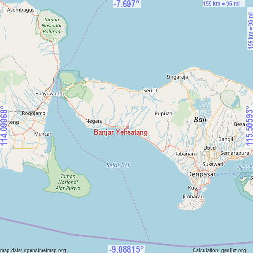
| Upper-left | -7.697°, | 114.09968° |
| Center: | -8.3932°, | 114.8028° |
| Lower-right: | -9.08815°, | 115.50593° |
| Map W x H: | 154.7×154.7 km | = 96.1×96.1mi |
| max Lat: | 5.88969° ⇑80.2% North |
| Banjar Yehsatang: | -8.3932° |
| min Lat: | ⇓19.8% South -10.934° |
| min Long | Banjar Yehsatan | max Long |
| 95.1345° | 114.8028° | 140.9419° |
| W 70.2%⇐ | ⇒29.8% E |
Elevation
Elevation of Banjar Yehsatang is 58 m = 190 ft, and this is 171.7 m = 563 ft below average elevation for this country.
| Max E: |
3185 m = 10449 ft | 60.3% |
| Avg. | 229.7 m = 754 ft | |
| Banjar Yehsatang | 58 m = 190 ft | |
Min E: |
-1 m = -3 ft | 39.7% |
See also: Indonesia elevation on elevation.city.
Geographical zone
Banjar Yehsatang is located in South Torrid zone (between Equator and Tropic of Capricorn). Distance of Equator is 933.2 km =579.9 mi to North.| Distance of | km | miles | from Banjar Yehsatang |
|---|---|---|---|
| Equator | 933.2 | 579.9 | to North |
| Tropic Capricorn | 1672.7 | 1039.4 | to South |
| Antarctic Circle | 6467.9 | 4019 | to South |
| South Pole | 9073.8 | 5638.2 | to South |


Nearby cities:
15 places around Banjar Yehsatang: (largest is in red/bold)
• Asahbadung
13.4 km =8.3 mi,  57°
57°
• Baler Baleagung
14.7 km =9.1 mi,  278°
278°
• Banjar Asahduren
5.5 km =3.4 mi,  95°
95°
• Banjar Dangin Pangkung
5.5 km =3.4 mi,  133°
133°
• Banjar Dauhmarga
14.3 km =8.9 mi,  270°
270°
• Banjar Delodsetra
1.8 km =1.1 mi,  110°
110°
• Banjar Mundukanggrek
6.8 km =4.2 mi, 284°
• Banjar Swastika
7.6 km =4.7 mi,  124°
124°
• Banjar Tegakgede
3 km =1.9 mi, 268°
• Banjar Tengah
15.2 km =9.4 mi, 281°
• Manggissari
10.4 km =6.5 mi,  77°
77°
• Munduk
14 km =8.7 mi, 280°
• Pekutatan
3.8 km =2.4 mi,  144°
144°
• Sepang
15.7 km =9.8 mi,  53°
53°
• Tista
13.8 km =8.6 mi,  70°
70°
Sources, notices
• [Note1] Compared only with cities in Indonesia existing in our database
• [Src1] Map data: © OpenStreetMap contributors (CC-BY-SA)
• [Src2] Other city data from geonames.org with taken over terms of usage.
• [Src3] Geographical zone / Annual Mean Temperature by Robert A. Rohde @ Wikipedia
