Buncrana geodata
Buncrana (Ulster) is a populated place; located in Ireland in Europe/Dublin (GMT+1) time zone. With population of 5,546 people, there are 122 cities with bigger population in this country. Compared to other cities in Ireland, 99.2% of cities are located further ↓South; 51.2% of cities are located further →East and 75.9% of cities have higher elevation than Buncrana. Note1


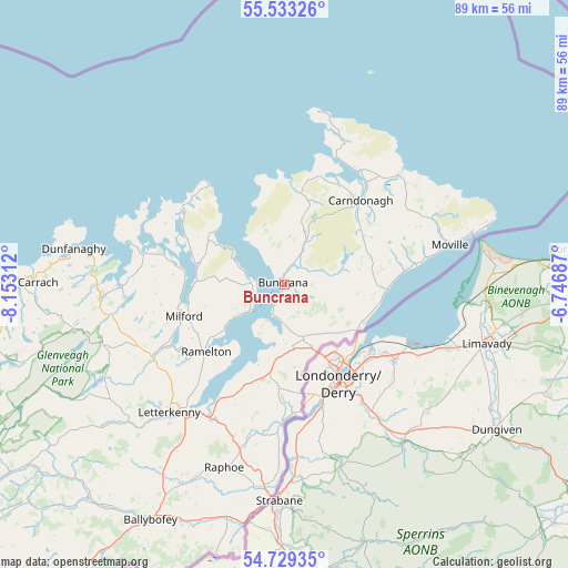
Buncrana GPS coordinates[2]
55° 7' 59.988" North, 7° 27' 0" West
| Map corner | latitude | longitude |
|---|---|---|
| Upper-left | 55.53326°, | -8.15312° |
| Center: | 55.13333°, | -7.45° |
| Lower-right: | 54.72935°, | -6.74687° |
| Map W x H: | 89.4×89.4 km | = 55.6×55.6mi |
| max Lat: | 55.25° ⇑0.8% North |
| Buncrana: | 55.13333° |
| min Lat: | ⇓99.2% South 51.52487° |
| min Long | Buncrana | max Long |
| -10.26889° | -7.45° | -6.04944° |
| W 48.8%⇐ | ⇒51.2% E |
Elevation
Elevation of Buncrana is 20 m = 66 ft, and this is 34.5 m = 113 ft below average elevation for this country.
| Max E: |
262 m = 860 ft | 75.9% |
| Avg. | 54.5 m = 179 ft | |
| Buncrana | 20 m = 66 ft | |
Min E: |
0 m = 0 ft | 24.1% |
See also: Ireland elevation on elevation.city.
Geographical zone
Buncrana is located in North temperate zone (between Tropic of Cancer and the Arctic Circle). Distance of this North polar circle is 1270.9 km =789.7 mi to North.| Distance of | km | miles | from Buncrana |
|---|---|---|---|
| North Pole | 3876.8 | 2408.9 | to North |
| Arctic Circle | 1270.9 | 789.7 | to North |
| Tropic Cancer | 3524.3 | 2189.9 | to South |
| Equator | 6130.3 | 3809.2 | to South |


Nearby cities:
15 places around Buncrana: (largest is in red/bold)
• Carndonagh
17.4 km =10.8 mi,  41°
41°
• Fahan
5.2 km =3.2 mi,  197°
197°
• Greencastle
30.6 km =19 mi,  75°
75°
• Kildrum
17.2 km =10.7 mi,  171°
171°
• Kilmacrenan
23.8 km =14.8 mi,  241°
241°
• Letterkenny
27.2 km =16.9 mi,  221°
221°
• Manorcunningham
23 km =14.3 mi,  207°
207°
• Millford
16.6 km =10.3 mi,  252°
252°
• Moville
26.9 km =16.7 mi, 76°
• Muff
13.8 km =8.6 mi,  122°
122°
• Newtown Cunningham
15.9 km =9.9 mi, 196°
• Ramelton
16.6 km =10.3 mi,  229°
229°
• Raphoe
30.3 km =18.8 mi, 198°
• Rathmullan
7.2 km =4.5 mi, 232°
• St Johnston
22 km =13.7 mi,  181°
181°
Sources, notices
• [Note1] Compared only with cities in Ireland existing in our database
• [Src1] Map data: © OpenStreetMap contributors (CC-BY-SA)
• [Src2] Other city data from geonames.org with taken over terms of usage.
• [Src3] Geographical zone / Annual Mean Temperature by Robert A. Rohde @ Wikipedia
