Ramelton geodata
Ramelton (Ulster) is a populated place; located in Ireland in Europe/Dublin (GMT+1) time zone. With population of 1,212 people, there are 310 cities with bigger population in this country. Compared to other cities in Ireland, 97.9% of cities are located further ↓South; 55.2% of cities are located further →East and 88% of cities have higher elevation than Ramelton. Note1


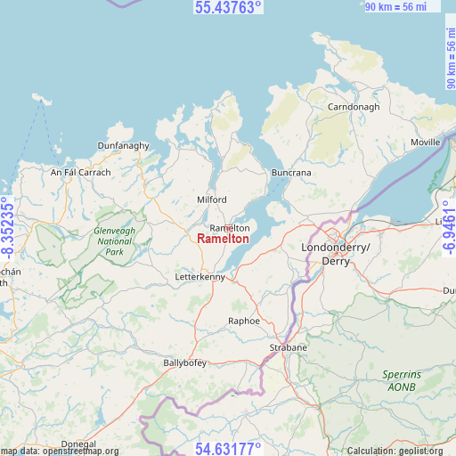
Ramelton GPS coordinates[2]
55° 2' 12.228" North, 7° 38' 57.228" West
| Map corner | latitude | longitude |
|---|---|---|
| Upper-left | 55.43763°, | -8.35235° |
| Center: | 55.03673°, | -7.64923° |
| Lower-right: | 54.63177°, | -6.9461° |
| Map W x H: | 89.6×89.6 km | = 55.7×55.7mi |
| max Lat: | 55.25° ⇑2.1% North |
| Ramelton: | 55.03673° |
| min Lat: | ⇓97.9% South 51.52487° |
| min Long | Ramelton | max Long |
| -10.26889° | -7.64923° | -6.04944° |
| W 44.8%⇐ | ⇒55.2% E |
Elevation
Elevation of Ramelton is 11 m = 36 ft, and this is 43.5 m = 143 ft below average elevation for this country.
| Max E: |
262 m = 860 ft | 88% |
| Avg. | 54.5 m = 179 ft | |
| Ramelton | 11 m = 36 ft | |
Min E: |
0 m = 0 ft | 12% |
See also: Ireland elevation on elevation.city.
Geographical zone
Ramelton is located in North temperate zone (between Tropic of Cancer and the Arctic Circle). Distance of this North polar circle is 1281.7 km =796.4 mi to North.| Distance of | km | miles | from Ramelton |
|---|---|---|---|
| North Pole | 3887.6 | 2415.6 | to North |
| Arctic Circle | 1281.7 | 796.4 | to North |
| Tropic Cancer | 3513.6 | 2183.2 | to South |
| Equator | 6119.5 | 3802.5 | to South |


Nearby cities:
15 places around Ramelton: (largest is in red/bold)
• Buncrana
16.6 km =10.3 mi,  49°
49°
• Castlefin
26.2 km =16.3 mi,  172°
172°
• Convoy
19.6 km =12.2 mi,  183°
183°
• Fahan
12.6 km =7.8 mi,  62°
62°
• Kildrum
16.4 km =10.2 mi,  112°
112°
• Kilmacrenan
8.3 km =5.2 mi,  265°
265°
• Leifear
25.1 km =15.6 mi,  155°
155°
• Letterkenny
11 km =6.8 mi,  209°
209°
• Manorcunningham
9.9 km =6.2 mi, 167°
• Millford
6.5 km =4 mi,  331°
331°
• Muff
24.6 km =15.3 mi,  82°
82°
• Newtown Cunningham
9.4 km =5.8 mi,  118°
118°
• Raphoe
18.3 km =11.4 mi, 169°
• Rathmullan
9.4 km =5.8 mi, 47°
• St Johnston
16.5 km =10.3 mi,  133°
133°
Sources, notices
• [Note1] Compared only with cities in Ireland existing in our database
• [Src1] Map data: © OpenStreetMap contributors (CC-BY-SA)
• [Src2] Other city data from geonames.org with taken over terms of usage.
• [Src3] Geographical zone / Annual Mean Temperature by Robert A. Rohde @ Wikipedia
