Newtown Cunningham geodata
Newtown Cunningham (Ulster) is a populated place; located in Ireland in Europe/Dublin (GMT+1) time zone. With population of 1,067 people, there are 336 cities with bigger population in this country. Compared to other cities in Ireland, 97.3% of cities are located further ↓South; 52.8% of cities are located further →East and 97.2% of cities have higher elevation than Newtown Cunningham. Note1


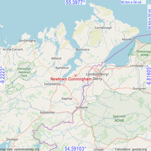
Newtown Cunningham GPS coordinates[2]
54° 59' 47.004" North, 7° 31' 9.012" West
| Map corner | latitude | longitude |
|---|---|---|
| Upper-left | 55.3977°, | -8.2223° |
| Center: | 54.99639°, | -7.51917° |
| Lower-right: | 54.59103°, | -6.81605° |
| Map W x H: | 89.7×89.7 km | = 55.7×55.7mi |
| max Lat: | 55.25° ⇑2.7% North |
| Newtown Cunningham: | 54.99639° |
| min Lat: | ⇓97.3% South 51.52487° |
| min Long | Newtown Cunning | max Long |
| -10.26889° | -7.51917° | -6.04944° |
| W 47.2%⇐ | ⇒52.8% E |
Elevation
Elevation of Newtown Cunningham is 5 m = 16 ft, and this is 49.5 m = 162 ft below average elevation for this country.
| Max E: |
262 m = 860 ft | 97.2% |
| Avg. | 54.5 m = 179 ft | |
| Newtown Cunningham | 5 m = 16 ft | |
Min E: |
0 m = 0 ft | 2.8% |
See also: Ireland elevation on elevation.city.
Geographical zone
Newtown Cunningham is located in North temperate zone (between Tropic of Cancer and the Arctic Circle). Distance of this North polar circle is 1286.1 km =799.1 mi to North.| Distance of | km | miles | from Newtown Cunningham |
|---|---|---|---|
| North Pole | 3892 | 2418.4 | to North |
| Arctic Circle | 1286.1 | 799.1 | to North |
| Tropic Cancer | 3509.1 | 2180.5 | to South |
| Equator | 6115 | 3799.7 | to South |


Nearby cities:
15 places around Newtown Cunningham: (largest is in red/bold)
• Buncrana
15.9 km =9.9 mi,  16°
16°
• Castlefin
22 km =13.7 mi,  192°
192°
• Convoy
17.7 km =11 mi,  211°
211°
• Fahan
10.6 km =6.6 mi, 15°
• Kildrum
7.1 km =4.4 mi,  105°
105°
• Kilmacrenan
17 km =10.6 mi,  283°
283°
• Leifear
18.4 km =11.4 mi,  172°
172°
• Letterkenny
14.6 km =9.1 mi,  249°
249°
• Manorcunningham
8.1 km =5 mi,  230°
230°
• Millford
15.3 km =9.5 mi,  311°
311°
• Muff
17.9 km =11.1 mi,  64°
64°
• Ramelton
9.4 km =5.8 mi,  298°
298°
• Raphoe
14.4 km =8.9 mi,  200°
200°
• Rathmullan
10.9 km =6.8 mi,  352°
352°
• St Johnston
7.7 km =4.8 mi,  151°
151°
Sources, notices
• [Note1] Compared only with cities in Ireland existing in our database
• [Src1] Map data: © OpenStreetMap contributors (CC-BY-SA)
• [Src2] Other city data from geonames.org with taken over terms of usage.
• [Src3] Geographical zone / Annual Mean Temperature by Robert A. Rohde @ Wikipedia
