Raheny geodata
Raheny (Leinster) is a populated place; located in Ireland in Europe/Dublin (GMT+1) time zone. With population of 7,197 people, there are 90 cities with bigger population in this country. Compared to other cities in Ireland, 64.1% of cities are located further ↓South; 92.6% of cities are located further ←West and 67.4% of cities have higher elevation than Raheny. Note1


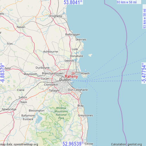
Raheny GPS coordinates[2]
53° 23' 12.516" North, 6° 10' 50.412" West
| Map corner | latitude | longitude |
|---|---|---|
| Upper-left | 53.8041°, | -6.88379° |
| Center: | 53.38681°, | -6.18067° |
| Lower-right: | 52.96539°, | -5.47754° |
| Map W x H: | 93.3×93.3 km | = 58×58mi |
| max Lat: | 55.25° ⇑35.9% North |
| Raheny: | 53.38681° |
| min Lat: | ⇓64.1% South 51.52487° |
| min Long | Raheny | max Long |
| -10.26889° | -6.18067° | -6.04944° |
| W 92.6%⇐ | ⇒7.4% E |
Elevation
Elevation of Raheny is 28 m = 92 ft, and this is 26.5 m = 87 ft below average elevation for this country.
| Max E: |
262 m = 860 ft | 67.4% |
| Avg. | 54.5 m = 179 ft | |
| Raheny | 28 m = 92 ft | |
Min E: |
0 m = 0 ft | 32.6% |
See also: Ireland elevation on elevation.city.
Geographical zone
Raheny is located in North temperate zone (between Tropic of Cancer and the Arctic Circle). Distance of this North polar circle is 1465.1 km =910.4 mi to North.| Distance of | km | miles | from Raheny |
|---|---|---|---|
| North Pole | 4071 | 2529.6 | to North |
| Arctic Circle | 1465.1 | 910.4 | to North |
| Tropic Cancer | 3330.1 | 2069.2 | to South |
| Equator | 5936.1 | 3688.5 | to South |


Nearby cities:
15 places around Raheny: (largest is in red/bold)
• Artane
2.2 km =1.4 mi,  270°
270°
• Baldoyle
3.9 km =2.4 mi,  68°
68°
• Bayside
2.7 km =1.7 mi,  84°
84°
• Beaumont
3.1 km =1.9 mi, 270°
• Bonnybrook
2.2 km =1.4 mi,  305°
305°
• Coolock
1.3 km =0.8 mi,  279°
279°
• Darndale
1.5 km =0.9 mi,  338°
338°
• Dollymount
2.4 km =1.5 mi,  179°
179°
• Donaghmede
1.8 km =1.1 mi,  44°
44°
• Donnycarney
2.4 km =1.5 mi,  232°
232°
• Fairview
4.6 km =2.9 mi,  239°
239°
• Killester
2.2 km =1.4 mi, 226°
• Marino
4.1 km =2.5 mi, 243°
• Portmarnock
4.9 km =3 mi, 35°
• Sutton
4.7 km =2.9 mi,  86°
86°
Sources, notices
• [Note1] Compared only with cities in Ireland existing in our database
• [Src1] Map data: © OpenStreetMap contributors (CC-BY-SA)
• [Src2] Other city data from geonames.org with taken over terms of usage.
• [Src3] Geographical zone / Annual Mean Temperature by Robert A. Rohde @ Wikipedia
