Donnycarney geodata
Donnycarney (Leinster) is a section of populated place; located in Ireland in Europe/Dublin (GMT+1) time zone. With population of 7,660 people, there are 86 cities with bigger population in this country. Compared to other cities in Ireland, 63.2% of cities are located further ↓South; 90.5% of cities are located further ←West and 71.9% of cities have higher elevation than Donnycarney. Note1


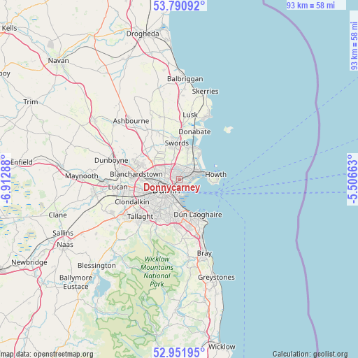
Donnycarney GPS coordinates[2]
53° 22' 24.6" North, 6° 12' 35.136" West
| Map corner | latitude | longitude |
|---|---|---|
| Upper-left | 53.79092°, | -6.91288° |
| Center: | 53.3735°, | -6.20976° |
| Lower-right: | 52.95195°, | -5.50663° |
| Map W x H: | 93.3×93.3 km | = 58×58mi |
| max Lat: | 55.25° ⇑36.8% North |
| Donnycarney: | 53.3735° |
| min Lat: | ⇓63.2% South 51.52487° |
| min Long | Donnycarney | max Long |
| -10.26889° | -6.20976° | -6.04944° |
| W 90.5%⇐ | ⇒9.5% E |
Elevation
Elevation of Donnycarney is 25 m = 82 ft, and this is 29.5 m = 97 ft below average elevation for this country.
| Max E: |
262 m = 860 ft | 71.9% |
| Avg. | 54.5 m = 179 ft | |
| Donnycarney | 25 m = 82 ft | |
Min E: |
0 m = 0 ft | 28.1% |
See also: Ireland elevation on elevation.city.
Geographical zone
Donnycarney is located in North temperate zone (between Tropic of Cancer and the Arctic Circle). Distance of this North polar circle is 1466.6 km =911.3 mi to North.| Distance of | km | miles | from Donnycarney |
|---|---|---|---|
| North Pole | 4072.5 | 2530.5 | to North |
| Arctic Circle | 1466.6 | 911.3 | to North |
| Tropic Cancer | 3328.7 | 2068.4 | to South |
| Equator | 5934.6 | 3687.6 | to South |


Nearby cities:
15 places around Donnycarney: (largest is in red/bold)
• Artane
1.5 km =0.9 mi,  349°
349°
• Ballymun
4.7 km =2.9 mi,  305°
305°
• Beaumont
1.9 km =1.2 mi,  322°
322°
• Bonnybrook
2.8 km =1.7 mi,  3°
3°
• Coolock
1.8 km =1.1 mi,  20°
20°
• Darndale
3.2 km =2 mi,  25°
25°
• Dollymount
2.2 km =1.4 mi,  116°
116°
• Donaghmede
4.2 km =2.6 mi,  48°
48°
• Drumcondra
2.9 km =1.8 mi,  263°
263°
• Fairview
2.2 km =1.4 mi,  247°
247°
• Glasnevin
4.7 km =2.9 mi,  276°
276°
• Killester
0.4 km =0.2 mi,  94°
94°
• Marino
1.8 km =1.1 mi, 258°
• Raheny
2.4 km =1.5 mi, 52°
• Ringsend
3.7 km =2.3 mi,  197°
197°
Sources, notices
• [Note1] Compared only with cities in Ireland existing in our database
• [Src1] Map data: © OpenStreetMap contributors (CC-BY-SA)
• [Src2] Other city data from geonames.org with taken over terms of usage.
• [Src3] Geographical zone / Annual Mean Temperature by Robert A. Rohde @ Wikipedia
