Killester geodata
Killester (Leinster) is a populated place; located in Ireland in Europe/Dublin (GMT+0) time zone. With population of 5,099 people, there are 132 cities with bigger population in this country. Compared to other cities in Ireland, 63% of cities are located further ↓South; 90.9% of cities are located further ←West and 73.1% of cities have higher elevation than Killester. Note1


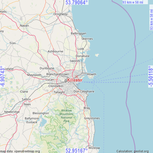
Killester GPS coordinates[2]
53° 22' 23.592" North, 6° 12' 15.516" West
| Map corner | latitude | longitude |
|---|---|---|
| Upper-left | 53.79064°, | -6.90743° |
| Center: | 53.37322°, | -6.20431° |
| Lower-right: | 52.95167°, | -5.50118° |
| Map W x H: | 93.3×93.3 km | = 58×58mi |
| max Lat: | 55.25° ⇑37% North |
| Killester: | 53.37322° |
| min Lat: | ⇓63% South 51.52487° |
| min Long | Killester | max Long |
| -10.26889° | -6.20431° | -6.04944° |
| W 90.9%⇐ | ⇒9.1% E |
Elevation
Elevation of Killester is 24 m = 79 ft, and this is 30.5 m = 100 ft below average elevation for this country.
| Max E: |
262 m = 860 ft | 73.1% |
| Avg. | 54.5 m = 179 ft | |
| Killester | 24 m = 79 ft | |
Min E: |
0 m = 0 ft | 26.9% |
See also: Ireland elevation on elevation.city.
Geographical zone
Killester is located in North temperate zone (between Tropic of Cancer and the Arctic Circle). Distance of this North polar circle is 1466.6 km =911.3 mi to North.| Distance of | km | miles | from Killester |
|---|---|---|---|
| North Pole | 4072.5 | 2530.5 | to North |
| Arctic Circle | 1466.6 | 911.3 | to North |
| Tropic Cancer | 3328.6 | 2068.3 | to South |
| Equator | 5934.5 | 3687.5 | to South |


Nearby cities:
15 places around Killester: (largest is in red/bold)
• Artane
1.7 km =1.1 mi,  337°
337°
• Ballymun
5 km =3.1 mi,  303°
303°
• Bayside
4.6 km =2.9 mi,  67°
67°
• Beaumont
2.2 km =1.4 mi,  315°
315°
• Bonnybrook
2.8 km =1.7 mi,  355°
355°
• Coolock
1.7 km =1.1 mi,  9°
9°
• Darndale
3.1 km =1.9 mi,  19°
19°
• Dollymount
1.8 km =1.1 mi,  120°
120°
• Donaghmede
4 km =2.5 mi,  45°
45°
• Donnycarney
0.4 km =0.2 mi,  274°
274°
• Drumcondra
3.2 km =2 mi,  264°
264°
• Fairview
2.5 km =1.6 mi,  251°
251°
• Marino
2.2 km =1.4 mi, 261°
• Raheny
2.2 km =1.4 mi, 46°
• Ringsend
3.8 km =2.4 mi,  202°
202°
Sources, notices
• [Note1] Compared only with cities in Ireland existing in our database
• [Src1] Map data: © OpenStreetMap contributors (CC-BY-SA)
• [Src2] Other city data from geonames.org with taken over terms of usage.
• [Src3] Geographical zone / Annual Mean Temperature by Robert A. Rohde @ Wikipedia
