Killygordon geodata
Killygordon (Ulster) is a populated place; located in Ireland in Europe/Dublin (GMT+1) time zone. With population of 608 people, there are 479 cities with bigger population in this country. Compared to other cities in Ireland, 95.1% of cities are located further ↓South; 55.8% of cities are located further →East and 55.4% of cities have lower elevation than Killygordon. Note1


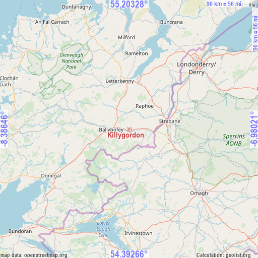
Killygordon GPS coordinates[2]
54° 48' 0" North, 7° 40' 59.988" West
| Map corner | latitude | longitude |
|---|---|---|
| Upper-left | 55.20328°, | -8.38646° |
| Center: | 54.8°, | -7.68333° |
| Lower-right: | 54.39266°, | -6.98021° |
| Map W x H: | 90.1×90.1 km | = 56×56mi |
| max Lat: | 55.25° ⇑4.9% North |
| Killygordon: | 54.8° |
| min Lat: | ⇓95.1% South 51.52487° |
| min Long | Killygordon | max Long |
| -10.26889° | -7.68333° | -6.04944° |
| W 44.2%⇐ | ⇒55.8% E |
Elevation
Elevation of Killygordon is 56 m = 184 ft, and this is 1.5 m = 5 ft above average elevation for this country.
| Max E: |
262 m = 860 ft | 44.6% |
| Killygordon | 56 m 184 ft | |
| Avg. | 54.5 m = 179 ft | |
Min E: |
0 m = 0 ft | 55.4% |
See also: Ireland elevation on elevation.city.
Geographical zone
Killygordon is located in North temperate zone (between Tropic of Cancer and the Arctic Circle). Distance of this North polar circle is 1308 km =812.8 mi to North.| Distance of | km | miles | from Killygordon |
|---|---|---|---|
| North Pole | 3913.9 | 2432 | to North |
| Arctic Circle | 1308 | 812.8 | to North |
| Tropic Cancer | 3487.3 | 2166.9 | to South |
| Equator | 6093.2 | 3786.1 | to South |


Nearby cities:
15 places around Killygordon: (largest is in red/bold)
• Ballybofey
6.4 km =4 mi,  270°
270°
• Ballybofey-Stranorlar
5.8 km =3.6 mi, 271°
• Castlefin
5.6 km =3.5 mi,  86°
86°
• Convoy
6.9 km =4.3 mi,  9°
9°
• Donegal
31.9 km =19.8 mi,  239°
239°
• Kildrum
26.5 km =16.5 mi,  40°
40°
• Kilmacrenan
26.4 km =16.4 mi,  346°
346°
• Leifear
13.3 km =8.3 mi,  74°
74°
• Letterkenny
17 km =10.6 mi, 349°
• Manorcunningham
17.2 km =10.7 mi, 14°
• Millford
32 km =19.9 mi,  358°
358°
• Newtown Cunningham
24.2 km =15 mi,  25°
25°
• Ramelton
26.4 km =16.4 mi,  4°
4°
• Raphoe
9.9 km =6.2 mi, 33°
• St Johnston
20.7 km =12.9 mi, 43°
Sources, notices
• [Note1] Compared only with cities in Ireland existing in our database
• [Src1] Map data: © OpenStreetMap contributors (CC-BY-SA)
• [Src2] Other city data from geonames.org with taken over terms of usage.
• [Src3] Geographical zone / Annual Mean Temperature by Robert A. Rohde @ Wikipedia
