Gweedore geodata
Gweedore (Ulster) is a populated place; located in Ireland in Europe/Dublin (GMT+1) time zone. With population of 4,200 people, there are 152 cities with bigger population in this country. Compared to other cities in Ireland, 98.1% of cities are located further ↓South; 67.4% of cities are located further →East and 59.8% of cities have lower elevation than Gweedore. Note1


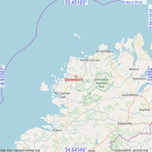
Gweedore GPS coordinates[2]
55° 3' 1.008" North, 8° 13' 54.984" West
| Map corner | latitude | longitude |
|---|---|---|
| Upper-left | 55.45105°, | -8.93507° |
| Center: | 55.05028°, | -8.23194° |
| Lower-right: | 54.64546°, | -7.52882° |
| Map W x H: | 89.6×89.6 km | = 55.7×55.7mi |
| max Lat: | 55.25° ⇑1.9% North |
| Gweedore: | 55.05028° |
| min Lat: | ⇓98.1% South 51.52487° |
| min Long | Gweedore | max Long |
| -10.26889° | -8.23194° | -6.04944° |
| W 32.6%⇐ | ⇒67.4% E |
Elevation
Elevation of Gweedore is 60 m = 197 ft, and this is 5.5 m = 18 ft above average elevation for this country.
| Max E: |
262 m = 860 ft | 40.2% |
| Gweedore | 60 m 197 ft | |
| Avg. | 54.5 m = 179 ft | |
Min E: |
0 m = 0 ft | 59.8% |
See also: Ireland elevation on elevation.city.
Geographical zone
Gweedore is located in North temperate zone (between Tropic of Cancer and the Arctic Circle). Distance of this North polar circle is 1280.2 km =795.5 mi to North.| Distance of | km | miles | from Gweedore |
|---|---|---|---|
| North Pole | 3886 | 2414.6 | to North |
| Arctic Circle | 1280.2 | 795.5 | to North |
| Tropic Cancer | 3515.1 | 2184.2 | to South |
| Equator | 6121 | 3803.4 | to South |


Nearby cities:
15 places around Gweedore: (largest is in red/bold)
• Ardara
33.7 km =20.9 mi,  199°
199°
• Ballybofey
40 km =24.9 mi,  134°
134°
• Ballybofey-Stranorlar
40.2 km =25 mi, 133°
• Convoy
41.8 km =26 mi,  120°
120°
• Derrybeg
5.2 km =3.2 mi,  315°
315°
• Dungloe
13.7 km =8.5 mi,  216°
216°
• Dunlewy
9.2 km =5.7 mi,  113°
113°
• Falcarragh
12.5 km =7.8 mi,  42°
42°
• Glenties
28.3 km =17.6 mi,  186°
186°
• Kilmacrenan
28.9 km =18 mi,  94°
94°
• Letterkenny
33.7 km =20.9 mi, 109°
• Manorcunningham
40.8 km =25.4 mi, 105°
• Millford
34.2 km =21.3 mi,  82°
82°
• Ramelton
37.2 km =23.1 mi, 92°
• Rathmullan
44.3 km =27.5 mi, 83°
Sources, notices
• [Note1] Compared only with cities in Ireland existing in our database
• [Src1] Map data: © OpenStreetMap contributors (CC-BY-SA)
• [Src2] Other city data from geonames.org with taken over terms of usage.
• [Src3] Geographical zone / Annual Mean Temperature by Robert A. Rohde @ Wikipedia
