Ardara geodata
Ardara (Ulster) is a populated place; located in Ireland in Europe/Dublin (GMT+1) time zone. With population of 731 people, there are 423 cities with bigger population in this country. Compared to other cities in Ireland, 94.7% of cities are located further ↓South; 72.1% of cities are located further →East and 60.2% of cities have higher elevation than Ardara. Note1


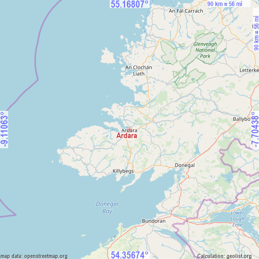
Ardara GPS coordinates[2]
54° 45' 51.984" North, 8° 24' 27" West
| Map corner | latitude | longitude |
|---|---|---|
| Upper-left | 55.16807°, | -9.11063° |
| Center: | 54.76444°, | -8.4075° |
| Lower-right: | 54.35674°, | -7.70438° |
| Map W x H: | 90.2×90.2 km | = 56×56mi |
| max Lat: | 55.25° ⇑5.3% North |
| Ardara: | 54.76444° |
| min Lat: | ⇓94.7% South 51.52487° |
| min Long | Ardara | max Long |
| -10.26889° | -8.4075° | -6.04944° |
| W 27.9%⇐ | ⇒72.1% E |
Elevation
Elevation of Ardara is 37 m = 121 ft, and this is 17.5 m = 57 ft below average elevation for this country.
| Max E: |
262 m = 860 ft | 60.2% |
| Avg. | 54.5 m = 179 ft | |
| Ardara | 37 m = 121 ft | |
Min E: |
0 m = 0 ft | 39.8% |
See also: Ireland elevation on elevation.city.
Geographical zone
Ardara is located in North temperate zone (between Tropic of Cancer and the Arctic Circle). Distance of this North polar circle is 1311.9 km =815.2 mi to North.| Distance of | km | miles | from Ardara |
|---|---|---|---|
| North Pole | 3917.8 | 2434.4 | to North |
| Arctic Circle | 1311.9 | 815.2 | to North |
| Tropic Cancer | 3483.3 | 2164.4 | to South |
| Equator | 6089.2 | 3783.7 | to South |


Nearby cities:
15 places around Ardara: (largest is in red/bold)
• Ballybofey
40.2 km =25 mi,  84°
84°
• Ballybofey-Stranorlar
40.8 km =25.4 mi, 84°
• Ballyshannon
32.8 km =20.4 mi,  153°
153°
• Bundoran
32.9 km =20.4 mi,  165°
165°
• Derrybeg
36.3 km =22.6 mi,  12°
12°
• Donegal
22.7 km =14.1 mi,  122°
122°
• Dungloe
21 km =13 mi, 8°
• Dunlewy
34.3 km =21.3 mi,  35°
35°
• Falcarragh
45.5 km =28.3 mi,  25°
25°
• Glenties
8.8 km =5.5 mi,  65°
65°
• Grange
42 km =26.1 mi,  190°
190°
• Gweedore
33.7 km =20.9 mi,  19°
19°
• Killybegs
14.8 km =9.2 mi, 190°
• Killygordon
46.6 km =29 mi,  85°
85°
• Kinlough
35.9 km =22.3 mi, 167°
Sources, notices
• [Note1] Compared only with cities in Ireland existing in our database
• [Src1] Map data: © OpenStreetMap contributors (CC-BY-SA)
• [Src2] Other city data from geonames.org with taken over terms of usage.
• [Src3] Geographical zone / Annual Mean Temperature by Robert A. Rohde @ Wikipedia
