Ballyshannon geodata
Ballyshannon (Ulster) is a populated place; located in Ireland in Europe/Dublin (GMT+1) time zone. With population of 2,683 people, there are 196 cities with bigger population in this country. Compared to other cities in Ireland, 94.1% of cities are located further ↓South; 65.8% of cities are located further →East and 92.6% of cities have higher elevation than Ballyshannon. Note1


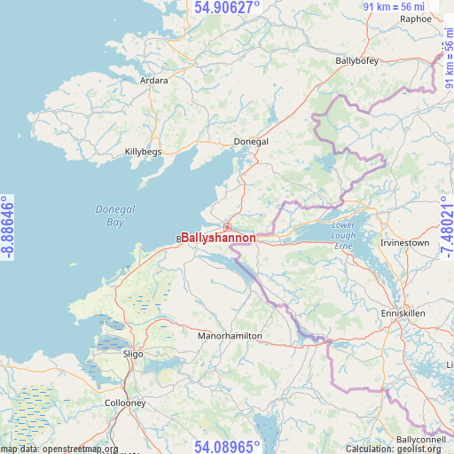
Ballyshannon GPS coordinates[2]
54° 30' 0" North, 8° 10' 59.988" West
| Map corner | latitude | longitude |
|---|---|---|
| Upper-left | 54.90627°, | -8.88646° |
| Center: | 54.5°, | -8.18333° |
| Lower-right: | 54.08965°, | -7.48021° |
| Map W x H: | 90.8×90.8 km | = 56.4×56.4mi |
| max Lat: | 55.25° ⇑5.9% North |
| Ballyshannon: | 54.5° |
| min Lat: | ⇓94.1% South 51.52487° |
| min Long | Ballyshannon | max Long |
| -10.26889° | -8.18333° | -6.04944° |
| W 34.2%⇐ | ⇒65.8% E |
Elevation
Elevation of Ballyshannon is 8 m = 26 ft, and this is 46.5 m = 153 ft below average elevation for this country.
| Max E: |
262 m = 860 ft | 92.6% |
| Avg. | 54.5 m = 179 ft | |
| Ballyshannon | 8 m = 26 ft | |
Min E: |
0 m = 0 ft | 7.4% |
See also: Ireland elevation on elevation.city.
Geographical zone
Ballyshannon is located in North temperate zone (between Tropic of Cancer and the Arctic Circle). Distance of this North polar circle is 1341.3 km =833.4 mi to North.| Distance of | km | miles | from Ballyshannon |
|---|---|---|---|
| North Pole | 3947.2 | 2452.7 | to North |
| Arctic Circle | 1341.3 | 833.4 | to North |
| Tropic Cancer | 3453.9 | 2146.2 | to South |
| Equator | 6059.8 | 3765.4 | to South |


Nearby cities:
15 places around Ballyshannon: (largest is in red/bold)
• Ardara
32.8 km =20.4 mi,  333°
333°
• Ballisodare
38.4 km =23.9 mi,  213°
213°
• Ballybofey
42.1 km =26.2 mi,  37°
37°
• Bundoran
6.8 km =4.2 mi,  248°
248°
• Collooney
40.8 km =25.4 mi, 210°
• Donegal
17.7 km =11 mi,  15°
15°
• Dromahair
30.6 km =19 mi,  194°
194°
• Glenties
33.7 km =20.9 mi,  349°
349°
• Grange
25.1 km =15.6 mi,  241°
241°
• Killybegs
22.7 km =14.1 mi,  310°
310°
• Kinlough
8.5 km =5.3 mi,  229°
229°
• Manorhamilton
21.5 km =13.4 mi,  178°
178°
• Rosses Point
32.6 km =20.3 mi, 229°
• Sligo
31.6 km =19.6 mi,  215°
215°
• Strandhill
36.7 km =22.8 mi, 226°
Sources, notices
• [Note1] Compared only with cities in Ireland existing in our database
• [Src1] Map data: © OpenStreetMap contributors (CC-BY-SA)
• [Src2] Other city data from geonames.org with taken over terms of usage.
• [Src3] Geographical zone / Annual Mean Temperature by Robert A. Rohde @ Wikipedia
