Tel Aviv geodata
Tel Aviv is a seat of a first-order administrative division; located in Israel in Asia/Jerusalem (GMT+3) time zone. With population of 432,892 people, there is 1 city with bigger population in this country. Compared to other cities in Israel, 60.9% of cities are located further ↑North; 91.7% of cities are located further →East and 93.5% of cities have higher elevation than Tel Aviv. Note1


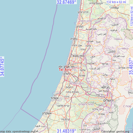
Tel Aviv GPS coordinates[2]
32° 4' 51.168" North, 34° 46' 50.052" East
| Map corner | latitude | longitude |
|---|---|---|
| Upper-left | 32.67469°, | 34.07745° |
| Center: | 32.08088°, | 34.78057° |
| Lower-right: | 31.48319°, | 35.4837° |
| Map W x H: | 132.5×132.5 km | = 82.3×82.3mi |
| max Lat: | 33.27918° ⇑60.9% North |
| Tel Aviv: | 32.08088° |
| min Lat: | ⇓39.1% South 29.55805° |
| min Long | Tel Aviv | max Long |
| 34.57149° | 34.78057° | 35.81084° |
| W 8.3%⇐ | ⇒91.7% E |
Elevation
Elevation of Tel Aviv is 15 m = 49 ft, and this is 208.4 m = 684 ft below average elevation for this country.
| Max E: |
988 m = 3241 ft | 93.5% |
| Avg. | 223.4 m = 733 ft | |
| Tel Aviv | 15 m = 49 ft | |
Min E: |
-380 m = -1247 ft | 6.5% |
See also: Tel Aviv elevation on elevation.city.
Geographical zone
Tel Aviv is located in North temperate zone (between Tropic of Cancer and the Arctic Circle). Distance of this Northern Tropic circle is 961.1 km =597.2 mi to South.| Distance of | km | miles | from Tel Aviv |
|---|---|---|---|
| North Pole | 6440 | 4001.6 | to North |
| Arctic Circle | 3834.1 | 2382.4 | to North |
| Tropic Cancer | 961.1 | 597.2 | to South |
| Equator | 3567.1 | 2216.5 | to South |


Nearby cities:
15 places around Tel Aviv: (largest is in red/bold)
• Azor
6.7 km =4.2 mi,  158°
158°
• Bat Yam
6.9 km =4.3 mi,  203°
203°
• Bet Dagan
9.9 km =6.2 mi,  152°
152°
• Bnei Brak
5 km =3.1 mi,  90°
90°
• Ganei Tikva
9 km =5.6 mi,  105°
105°
• Giv'at Shmuel
6.4 km =4 mi, 92°
• Givatayim
3.2 km =2 mi, 107°
• Herzliya
10.4 km =6.5 mi,  23°
23°
• H̱olon
7.8 km =4.8 mi,  180°
180°
• Jaffa
4.3 km =2.7 mi,  218°
218°
• Or Yehuda
9.3 km =5.8 mi,  128°
128°
• Petaẖ Tiqwa
10.1 km =6.3 mi, 86°
• Ramat Gan
2.8 km =1.7 mi, 86°
• Ramat HaSharon
9.1 km =5.7 mi,  37°
37°
• Savyon
9.8 km =6.1 mi, 110°
Sources, notices
• [Note1] Compared only with cities in Israel existing in our database
• [Src1] Map data: © OpenStreetMap contributors (CC-BY-SA)
• [Src2] Other city data from geonames.org with taken over terms of usage.
• [Src3] Geographical zone / Annual Mean Temperature by Robert A. Rohde @ Wikipedia
