Azor geodata
Azor (Tel Aviv) is a populated place; located in Israel in Asia/Jerusalem (GMT+3) time zone. With population of 16,201 people, there are 77 cities with bigger population in this country. Compared to other cities in Israel, 67.5% of cities are located further ↑North; 87.6% of cities are located further →East and 90.5% of cities have higher elevation than Azor. Note1


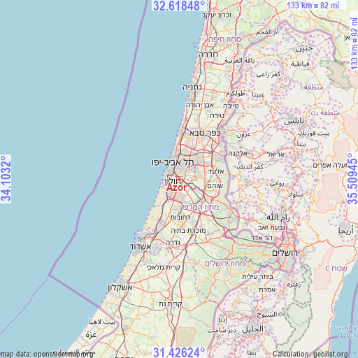
Azor GPS coordinates[2]
32° 1' 27.48" North, 34° 48' 22.752" East
| Map corner | latitude | longitude |
|---|---|---|
| Upper-left | 32.61848°, | 34.1032° |
| Center: | 32.0243°, | 34.80632° |
| Lower-right: | 31.42624°, | 35.50945° |
| Map W x H: | 132.6×132.6 km | = 82.4×82.4mi |
| max Lat: | 33.27918° ⇑67.5% North |
| Azor: | 32.0243° |
| min Lat: | ⇓32.5% South 29.55805° |
| min Long | Azor | max Long |
| 34.57149° | 34.80632° | 35.81084° |
| W 12.4%⇐ | ⇒87.6% E |
Elevation
Elevation of Azor is 25 m = 82 ft, and this is 198.4 m = 651 ft below average elevation for this country.
| Max E: |
988 m = 3241 ft | 90.5% |
| Avg. | 223.4 m = 733 ft | |
| Azor | 25 m = 82 ft | |
Min E: |
-380 m = -1247 ft | 9.5% |
See also: Israel elevation on elevation.city.
Geographical zone
Azor is located in North temperate zone (between Tropic of Cancer and the Arctic Circle). Distance of this Northern Tropic circle is 954.8 km =593.3 mi to South.| Distance of | km | miles | from Azor |
|---|---|---|---|
| North Pole | 6446.3 | 4005.5 | to North |
| Arctic Circle | 3840.4 | 2386.3 | to North |
| Tropic Cancer | 954.8 | 593.3 | to South |
| Equator | 3560.8 | 2212.6 | to South |


Nearby cities:
15 places around Azor: (largest is in red/bold)
• Bat Yam
5.1 km =3.2 mi,  269°
269°
• Bet Dagan
3.3 km =2.1 mi,  138°
138°
• Bnei Brak
6.8 km =4.2 mi,  22°
22°
• Ganei Tikva
7.4 km =4.6 mi,  58°
58°
• Giv'at Shmuel
7.2 km =4.5 mi,  33°
33°
• Givatayim
5.4 km =3.4 mi,  6°
6°
• H̱olon
3 km =1.9 mi,  238°
238°
• Jaffa
5.9 km =3.7 mi,  299°
299°
• Kefar H̱abad
5.9 km =3.7 mi,  133°
133°
• Or Yehuda
4.9 km =3 mi,  83°
83°
• Ramat Gan
6.5 km =4 mi,  3°
3°
• Rishon LeẔiyyon
6.1 km =3.8 mi,  195°
195°
• Savyon
7.3 km =4.5 mi,  67°
67°
• Tel Aviv
6.7 km =4.2 mi,  338°
338°
• Yehud-Monosson
6.9 km =4.3 mi,  86°
86°
Sources, notices
• [Note1] Compared only with cities in Israel existing in our database
• [Src1] Map data: © OpenStreetMap contributors (CC-BY-SA)
• [Src2] Other city data from geonames.org with taken over terms of usage.
• [Src3] Geographical zone / Annual Mean Temperature by Robert A. Rohde @ Wikipedia
