Qiryat Gat geodata
Qiryat Gat (Southern District) is a populated place; located in Israel in Asia/Jerusalem (GMT+3) time zone. With population of 47,450 people, there are 29 cities with bigger population in this country. Compared to other cities in Israel, 91.7% of cities are located further ↑North; 93.5% of cities are located further →East and 53.3% of cities have lower elevation than Qiryat Gat. Note1


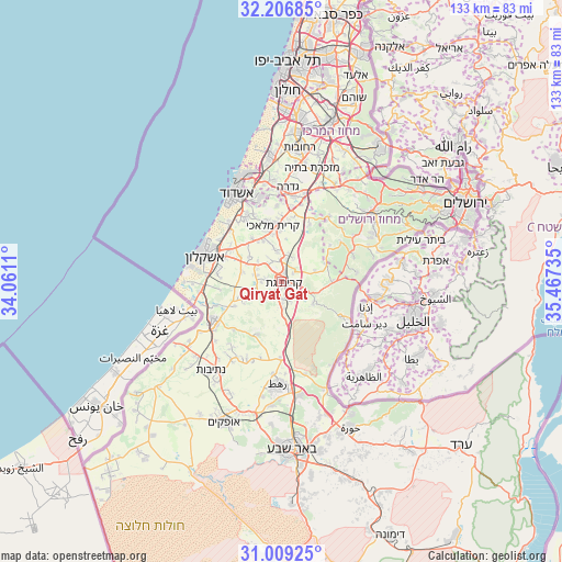
Qiryat Gat GPS coordinates[2]
31° 36' 35.928" North, 34° 45' 51.192" East
| Map corner | latitude | longitude |
|---|---|---|
| Upper-left | 32.20685°, | 34.0611° |
| Center: | 31.60998°, | 34.76422° |
| Lower-right: | 31.00925°, | 35.46735° |
| Map W x H: | 133.2×133.2 km | = 82.8×82.8mi |
| max Lat: | 33.27918° ⇑91.7% North |
| Qiryat Gat: | 31.60998° |
| min Lat: | ⇓8.3% South 29.55805° |
| min Long | Qiryat Gat | max Long |
| 34.57149° | 34.76422° | 35.81084° |
| W 6.5%⇐ | ⇒93.5% E |
Elevation
Elevation of Qiryat Gat is 133 m = 436 ft, and this is 90.4 m = 297 ft below average elevation for this country.
| Max E: |
988 m = 3241 ft | 46.7% |
| Avg. | 223.4 m = 733 ft | |
| Qiryat Gat | 133 m = 436 ft | |
Min E: |
-380 m = -1247 ft | 53.3% |
See also: Qiryat Gat elevation on elevation.city.
Geographical zone
Qiryat Gat is located in North temperate zone (between Tropic of Cancer and the Arctic Circle). Distance of this Northern Tropic circle is 908.8 km =564.7 mi to South.| Distance of | km | miles | from Qiryat Gat |
|---|---|---|---|
| North Pole | 6492.4 | 4034.2 | to North |
| Arctic Circle | 3886.5 | 2415 | to North |
| Tropic Cancer | 908.8 | 564.7 | to South |
| Equator | 3514.7 | 2183.9 | to South |


Nearby cities:
15 places around Qiryat Gat: (largest is in red/bold)
• Ashdod
23 km =14.3 mi,  331°
331°
• Ashkelon
19.4 km =12.1 mi,  289°
289°
• Bet Shemesh
25.5 km =15.8 mi,  58°
58°
• Bnei Ayish
19.3 km =12 mi,  356°
356°
• Gan Yavne
20.5 km =12.7 mi,  344°
344°
• Gedera
22.8 km =14.2 mi,  3°
3°
• Lehavim
26.8 km =16.7 mi,  169°
169°
• Mazkeret Batya
28.2 km =17.5 mi,  16°
16°
• Mevo Betar
34.7 km =21.6 mi,  69°
69°
• Netivot
26.6 km =16.5 mi,  218°
218°
• Rahat
23.9 km =14.9 mi,  181°
181°
• Reẖovot
31.9 km =19.8 mi,  8°
8°
• Sederot
18.5 km =11.5 mi,  239°
239°
• Yavné
29.9 km =18.6 mi, 355°
• Ẕur Hadassa
33.8 km =21 mi, 68°
Sources, notices
• [Note1] Compared only with cities in Israel existing in our database
• [Src1] Map data: © OpenStreetMap contributors (CC-BY-SA)
• [Src2] Other city data from geonames.org with taken over terms of usage.
• [Src3] Geographical zone / Annual Mean Temperature by Robert A. Rohde @ Wikipedia
