Injambakkam geodata
Injambakkam (Tamil Nadu) is a populated place; located in India in Asia/Kolkata (GMT+5.5) time zone. With population of 23,346 people, there are 1814 cities with bigger population in this country. Compared to other cities in India, 87% of cities are located further ↑North; 69.9% of cities are located further ←West and 98.3% of cities have higher elevation than Injambakkam. Note1


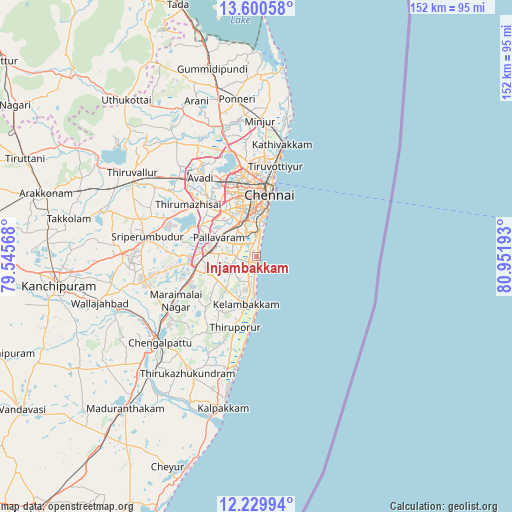
Injambakkam GPS coordinates[2]
12° 54' 58.32" North, 80° 14' 55.68" East
| Map corner | latitude | longitude |
|---|---|---|
| Upper-left | 13.60058°, | 79.54568° |
| Center: | 12.9162°, | 80.2488° |
| Lower-right: | 12.22994°, | 80.95193° |
| Map W x H: | 152.4×152.4 km | = 94.7×94.7mi |
| max Lat: | 34.9274° ⇑87% North |
| Injambakkam: | 12.9162° |
| min Lat: | ⇓13% South 8.09008° |
| min Long | Injambakkam | max Long |
| 68.82655° | 80.2488° | 96.81° |
| W 69.9%⇐ | ⇒30.1% E |
Elevation
Elevation of Injambakkam is 8 m = 26 ft, and this is 287.6 m = 944 ft below average elevation for this country.
| Max E: |
3681 m = 12077 ft | 98.3% |
| Avg. | 295.6 m = 970 ft | |
| Injambakkam | 8 m = 26 ft | |
Min E: |
1 m = 3 ft | 1.7% |
See also: India elevation on elevation.city.
Geographical zone
Injambakkam is located in North Torrid zone (between Equator and Tropic of Cancer). Distance of this Northern Tropic circle is 1169.8 km =726.9 mi to North.| Distance of | km | miles | from Injambakkam |
|---|---|---|---|
| North Pole | 8570.9 | 5325.7 | to North |
| Arctic Circle | 5965 | 3706.5 | to North |
| Tropic Cancer | 1169.8 | 726.9 | to North |
| Equator | 1436.1 | 892.4 | to South |


Nearby cities:
15 places around Injambakkam: (largest is in red/bold)
• Alandur
10.7 km =6.6 mi,  334°
334°
• Chennai
19.4 km =12.1 mi,  9°
9°
• Chetput
17.1 km =10.6 mi,  357°
357°
• Gāndhī Nagar
10 km =6.2 mi,  3°
3°
• Madipakkam
7.5 km =4.7 mi,  313°
313°
• Manappakkam
13.6 km =8.5 mi,  320°
320°
• Neelankarai
3.9 km =2.4 mi,  16°
16°
• Palavakkam
4.2 km =2.6 mi, 12°
• Pallāvaram
12.1 km =7.5 mi,  298°
298°
• Perungudi
5 km =3.1 mi,  350°
350°
• Porur
16.5 km =10.3 mi, 323°
• Saint Thomas Mount
11.2 km =7 mi, 329°
• Tambaram
13.2 km =8.2 mi,  274°
274°
• Vandalūr
18.4 km =11.4 mi,  261°
261°
• Vengavasal
8.9 km =5.5 mi, 257°
Sources, notices
• [Note1] Compared only with cities in India existing in our database
• [Src1] Map data: © OpenStreetMap contributors (CC-BY-SA)
• [Src2] Other city data from geonames.org with taken over terms of usage.
• [Src3] Geographical zone / Annual Mean Temperature by Robert A. Rohde @ Wikipedia
