Alandur geodata
Alandur (Tamil Nadu) is a section of populated place; located in India in Asia/Kolkata (GMT+5.5) time zone. With population of 153,775 people, there are 281 cities with bigger population in this country. Compared to other cities in India, 86.3% of cities are located further ↑North; 69.7% of cities are located further ←West and 91.9% of cities have higher elevation than Alandur. Note1


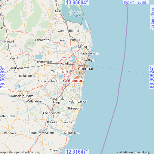
Alandur GPS coordinates[2]
13° 0' 9" North, 80° 12' 21.996" East
| Map corner | latitude | longitude |
|---|---|---|
| Upper-left | 13.68664°, | 79.50299° |
| Center: | 13.0025°, | 80.20611° |
| Lower-right: | 12.31647°, | 80.90924° |
| Map W x H: | 152.3×152.4 km | = 94.6×94.7mi |
| max Lat: | 34.9274° ⇑86.3% North |
| Alandur: | 13.0025° |
| min Lat: | ⇓13.7% South 8.09008° |
| min Long | Alandur | max Long |
| 68.82655° | 80.20611° | 96.81° |
| W 69.7%⇐ | ⇒30.3% E |
Elevation
Elevation of Alandur is 15 m = 49 ft, and this is 280.6 m = 921 ft below average elevation for this country.
| Max E: |
3681 m = 12077 ft | 91.9% |
| Avg. | 295.6 m = 970 ft | |
| Alandur | 15 m = 49 ft | |
Min E: |
1 m = 3 ft | 8.1% |
See also: Alandur elevation on elevation.city.
Geographical zone
Alandur is located in North Torrid zone (between Equator and Tropic of Cancer). Distance of this Northern Tropic circle is 1160.2 km =720.9 mi to North.| Distance of | km | miles | from Alandur |
|---|---|---|---|
| North Pole | 8561.3 | 5319.7 | to North |
| Arctic Circle | 5955.4 | 3700.5 | to North |
| Tropic Cancer | 1160.2 | 720.9 | to North |
| Equator | 1445.7 | 898.3 | to South |


Nearby cities:
15 places around Alandur: (largest is in red/bold)
• Ambattūr
11.7 km =7.3 mi,  335°
335°
• Chetput
8.4 km =5.2 mi,  26°
26°
• Gāndhī Nagar
5.2 km =3.2 mi,  85°
85°
• Injambakkam
10.7 km =6.6 mi,  154°
154°
• Madipakkam
4.5 km =2.8 mi,  190°
190°
• Manappakkam
4.2 km =2.6 mi,  282°
282°
• Neelankarai
8.2 km =5.1 mi,  135°
135°
• Palavakkam
7.8 km =4.8 mi,  134°
134°
• Pallāvaram
7.2 km =4.5 mi,  237°
237°
• Perungudi
6 km =3.7 mi, 140°
• Poonamalle
11.1 km =6.9 mi,  297°
297°
• Porur
6.4 km =4 mi,  305°
305°
• Saint Thomas Mount
1.1 km =0.7 mi,  274°
274°
• Tambaram
12.2 km =7.6 mi,  224°
224°
• Vengavasal
12.2 km =7.6 mi,  199°
199°
Sources, notices
• [Note1] Compared only with cities in India existing in our database
• [Src1] Map data: © OpenStreetMap contributors (CC-BY-SA)
• [Src2] Other city data from geonames.org with taken over terms of usage.
• [Src3] Geographical zone / Annual Mean Temperature by Robert A. Rohde @ Wikipedia
