Sīrkāzhi geodata
Sīrkāzhi (Tamil Nadu) is a populated place; located in India in Asia/Kolkata (GMT+5.5) time zone. With population of 33,100 people, there are 1315 cities with bigger population in this country. Compared to other cities in India, 92.3% of cities are located further ↑North; 66% of cities are located further ←West and 94.3% of cities have higher elevation than Sīrkāzhi. Note1


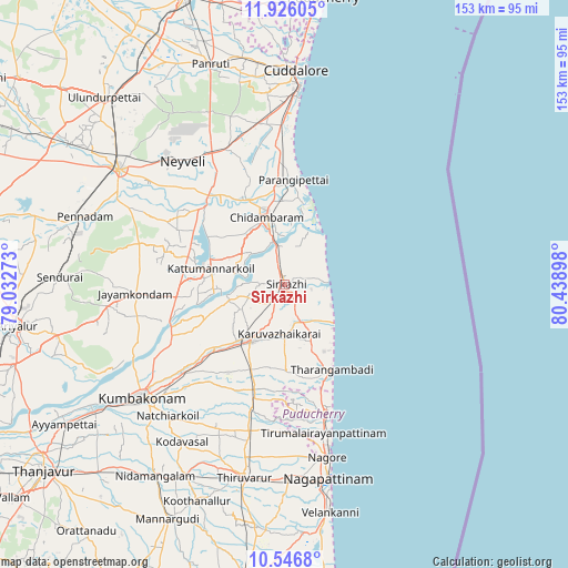
Sīrkāzhi GPS coordinates[2]
11° 14' 14.1" North, 79° 44' 9.06" East
| Map corner | latitude | longitude |
|---|---|---|
| Upper-left | 11.92605°, | 79.03273° |
| Center: | 11.23725°, | 79.73585° |
| Lower-right: | 10.5468°, | 80.43898° |
| Map W x H: | 153.4×153.4 km | = 95.3×95.3mi |
| max Lat: | 34.9274° ⇑92.3% North |
| Sīrkāzhi: | 11.23725° |
| min Lat: | ⇓7.7% South 8.09008° |
| min Long | Sīrkāzhi | max Long |
| 68.82655° | 79.73585° | 96.81° |
| W 66%⇐ | ⇒34% E |
Elevation
Elevation of Sīrkāzhi is 12 m = 39 ft, and this is 283.6 m = 930 ft below average elevation for this country.
| Max E: |
3681 m = 12077 ft | 94.3% |
| Avg. | 295.6 m = 970 ft | |
| Sīrkāzhi | 12 m = 39 ft | |
Min E: |
1 m = 3 ft | 5.7% |
See also: India elevation on elevation.city.
Geographical zone
Sīrkāzhi is located in North Torrid zone (between Equator and Tropic of Cancer). Distance of Equator is 1249.5 km =776.4 mi to South.| Distance of | km | miles | from Sīrkāzhi |
|---|---|---|---|
| North Pole | 8757.6 | 5441.7 | to North |
| Arctic Circle | 6151.7 | 3822.5 | to North |
| Tropic Cancer | 1356.5 | 842.9 | to North |
| Equator | 1249.5 | 776.4 | to South |


Nearby cities:
15 places around Sīrkāzhi: (largest is in red/bold)
• Aduthurai
37.2 km =23.1 mi,  228°
228°
• Annāmalainagar
18.1 km =11.2 mi,  359°
359°
• Chidambaram
18.7 km =11.6 mi,  344°
344°
• Jayamkondacholapuram
40.7 km =25.3 mi,  266°
266°
• Kumbakonam
48.5 km =30.1 mi, 230°
• Kurinjippādi
38.2 km =23.7 mi, 335°
• Kāraikāl
37.2 km =23.1 mi,  163°
163°
• Kīl Bhuvanagiri
24.7 km =15.3 mi, 337°
• Mayiladuthurai
17.3 km =10.7 mi,  210°
210°
• Nannilam
42.1 km =26.2 mi,  198°
198°
• Srīmushnam
40.5 km =25.2 mi,  296°
296°
• Tharangambadi
26.6 km =16.5 mi,  151°
151°
• Thiruvidaimaruthur
40.8 km =25.4 mi, 229°
• Tirumullaivāsal
11 km =6.8 mi,  88°
88°
• Ālappākkam
40.3 km =25 mi, 357°
Sources, notices
• [Note1] Compared only with cities in India existing in our database
• [Src1] Map data: © OpenStreetMap contributors (CC-BY-SA)
• [Src2] Other city data from geonames.org with taken over terms of usage.
• [Src3] Geographical zone / Annual Mean Temperature by Robert A. Rohde @ Wikipedia
