Srīmushnam geodata
Srīmushnam (Tamil Nadu) is a populated place; located in India in Asia/Kolkata (GMT+5.5) time zone. With population of 12,364 people, there are 2713 cities with bigger population in this country. Compared to other cities in India, 91.7% of cities are located further ↑North; 62.6% of cities are located further ←West and 84.2% of cities have higher elevation than Srīmushnam. Note1


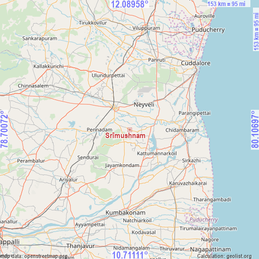
Srīmushnam GPS coordinates[2]
11° 24' 4.248" North, 79° 24' 13.824" East
| Map corner | latitude | longitude |
|---|---|---|
| Upper-left | 12.08958°, | 78.70072° |
| Center: | 11.40118°, | 79.40384° |
| Lower-right: | 10.71111°, | 80.10697° |
| Map W x H: | 153.3×153.3 km | = 95.3×95.3mi |
| max Lat: | 34.9274° ⇑91.7% North |
| Srīmushnam: | 11.40118° |
| min Lat: | ⇓8.3% South 8.09008° |
| min Long | Srīmushnam | max Long |
| 68.82655° | 79.40384° | 96.81° |
| W 62.6%⇐ | ⇒37.4% E |
Elevation
Elevation of Srīmushnam is 33 m = 108 ft, and this is 262.6 m = 862 ft below average elevation for this country.
| Max E: |
3681 m = 12077 ft | 84.2% |
| Avg. | 295.6 m = 970 ft | |
| Srīmushnam | 33 m = 108 ft | |
Min E: |
1 m = 3 ft | 15.8% |
See also: India elevation on elevation.city.
Geographical zone
Srīmushnam is located in North Torrid zone (between Equator and Tropic of Cancer). Distance of Equator is 1267.7 km =787.7 mi to South.| Distance of | km | miles | from Srīmushnam |
|---|---|---|---|
| North Pole | 8739.4 | 5430.4 | to North |
| Arctic Circle | 6133.5 | 3811.2 | to North |
| Tropic Cancer | 1338.2 | 831.5 | to North |
| Equator | 1267.7 | 787.7 | to South |


Nearby cities:
15 places around Srīmushnam: (largest is in red/bold)
• Aduthurai
43.7 km =27.2 mi,  168°
168°
• Annāmalainagar
35.9 km =22.3 mi,  90°
90°
• Ariyalūr
46.2 km =28.7 mi,  230°
230°
• Chidambaram
31.3 km =19.4 mi, 90°
• Jayamkondacholapuram
21.4 km =13.3 mi,  191°
191°
• Kurinjippādi
26.3 km =16.3 mi,  50°
50°
• Kīl Bhuvanagiri
27 km =16.8 mi,  80°
80°
• Mayiladuthurai
43 km =26.7 mi,  140°
140°
• Māttūr
23.7 km =14.7 mi,  248°
248°
• Panruti
44.8 km =27.8 mi,  21°
21°
• Pennādam
17.7 km =11 mi,  270°
270°
• Sīrkāzhi
40.5 km =25.2 mi,  116°
116°
• Thiruvidaimaruthur
45.1 km =28 mi, 173°
• Vriddhāchalam
15.7 km =9.8 mi,  326°
326°
• Ālappākkam
40.8 km =25.4 mi,  57°
57°
Sources, notices
• [Note1] Compared only with cities in India existing in our database
• [Src1] Map data: © OpenStreetMap contributors (CC-BY-SA)
• [Src2] Other city data from geonames.org with taken over terms of usage.
• [Src3] Geographical zone / Annual Mean Temperature by Robert A. Rohde @ Wikipedia
