Serula geodata
Serula (Goa) is a populated place; located in India in Asia/Kolkata (GMT+5.5) time zone. With population of 10,631 people, there are 2879 cities with bigger population in this country. Compared to other cities in India, 79.5% of cities are located further ↑North; 90.8% of cities are located further →East and 81.4% of cities have higher elevation than Serula. Note1


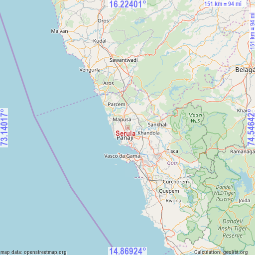
Serula GPS coordinates[2]
15° 32' 51.864" North, 73° 50' 35.844" East
| Map corner | latitude | longitude |
|---|---|---|
| Upper-left | 16.22401°, | 73.14017° |
| Center: | 15.54774°, | 73.84329° |
| Lower-right: | 14.86924°, | 74.54642° |
| Map W x H: | 150.6×150.6 km | = 93.6×93.6mi |
| max Lat: | 34.9274° ⇑79.5% North |
| Serula: | 15.54774° |
| min Lat: | ⇓20.5% South 8.09008° |
| min Long | Serula | max Long |
| 68.82655° | 73.84329° | 96.81° |
| W 9.2%⇐ | ⇒90.8% E |
Elevation
Elevation of Serula is 43 m = 141 ft, and this is 252.6 m = 829 ft below average elevation for this country.
| Max E: |
3681 m = 12077 ft | 81.4% |
| Avg. | 295.6 m = 970 ft | |
| Serula | 43 m = 141 ft | |
Min E: |
1 m = 3 ft | 18.6% |
See also: India elevation on elevation.city.
Geographical zone
Serula is located in North Torrid zone (between Equator and Tropic of Cancer). Distance of this Northern Tropic circle is 877.2 km =545.1 mi to North.| Distance of | km | miles | from Serula |
|---|---|---|---|
| North Pole | 8278.3 | 5143.9 | to North |
| Arctic Circle | 5672.4 | 3524.7 | to North |
| Tropic Cancer | 877.2 | 545.1 | to North |
| Equator | 1728.7 | 1074.2 | to South |


Nearby cities:
15 places around Serula: (largest is in red/bold)
• Aldona
6.1 km =3.8 mi,  33°
33°
• Baga
9.6 km =6 mi,  281°
281°
• Bambolim
9.4 km =5.8 mi,  173°
173°
• Calangute
9.4 km =5.8 mi,  267°
267°
• Candolim
9.3 km =5.8 mi,  249°
249°
• Colovale
9.9 km =6.2 mi,  348°
348°
• Guirim
4.9 km =3 mi,  308°
308°
• Jua
11.6 km =7.2 mi,  99°
99°
• Māpuca
6.1 km =3.8 mi,  322°
322°
• Panaji
6.1 km =3.8 mi,  197°
197°
• Saligao
5.7 km =3.5 mi, 276°
• Sinquerim
9.3 km =5.8 mi,  238°
238°
• Solim
11.1 km =6.9 mi, 312°
• Taleigao
8.8 km =5.5 mi,  187°
187°
• Vagator
11.9 km =7.4 mi,  297°
297°
Sources, notices
• [Note1] Compared only with cities in India existing in our database
• [Src1] Map data: © OpenStreetMap contributors (CC-BY-SA)
• [Src2] Other city data from geonames.org with taken over terms of usage.
• [Src3] Geographical zone / Annual Mean Temperature by Robert A. Rohde @ Wikipedia
