Aldona geodata
Aldona (Goa) is a populated place; located in India in Asia/Kolkata (GMT+5.5) time zone. With population of 6,606 people, there are 3240 cities with bigger population in this country. Compared to other cities in India, 79.2% of cities are located further ↑North; 90.5% of cities are located further →East and 90.4% of cities have higher elevation than Aldona. Note1


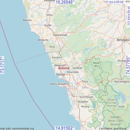
Aldona GPS coordinates[2]
15° 35' 36.132" North, 73° 52' 29.352" East
| Map corner | latitude | longitude |
|---|---|---|
| Upper-left | 16.26948°, | 73.1717° |
| Center: | 15.59337°, | 73.87482° |
| Lower-right: | 14.91502°, | 74.57795° |
| Map W x H: | 150.6×150.6 km | = 93.6×93.6mi |
| max Lat: | 34.9274° ⇑79.2% North |
| Aldona: | 15.59337° |
| min Lat: | ⇓20.8% South 8.09008° |
| min Long | Aldona | max Long |
| 68.82655° | 73.87482° | 96.81° |
| W 9.5%⇐ | ⇒90.5% E |
Elevation
Elevation of Aldona is 17 m = 56 ft, and this is 278.6 m = 914 ft below average elevation for this country.
| Max E: |
3681 m = 12077 ft | 90.4% |
| Avg. | 295.6 m = 970 ft | |
| Aldona | 17 m = 56 ft | |
Min E: |
1 m = 3 ft | 9.6% |
See also: India elevation on elevation.city.
Geographical zone
Aldona is located in North Torrid zone (between Equator and Tropic of Cancer). Distance of this Northern Tropic circle is 872.1 km =541.9 mi to North.| Distance of | km | miles | from Aldona |
|---|---|---|---|
| North Pole | 8273.2 | 5140.7 | to North |
| Arctic Circle | 5667.4 | 3521.6 | to North |
| Tropic Cancer | 872.1 | 541.9 | to North |
| Equator | 1733.8 | 1077.3 | to South |


Nearby cities:
15 places around Aldona: (largest is in red/bold)
• Baga
13.2 km =8.2 mi,  256°
256°
• Calangute
13.9 km =8.6 mi,  246°
246°
• Carapur
12.4 km =7.7 mi,  104°
104°
• Colovale
7.1 km =4.4 mi,  310°
310°
• Dicholi
7.6 km =4.7 mi,  90°
90°
• Guirim
7.5 km =4.7 mi, 254°
• Jua
10.7 km =6.6 mi,  130°
130°
• Māpuca
7.1 km =4.4 mi,  268°
268°
• Navelim
13.4 km =8.3 mi,  119°
119°
• Panaji
12 km =7.5 mi,  205°
205°
• Saligao
10.1 km =6.3 mi,  243°
243°
• Serula
6.1 km =3.8 mi, 213°
• Solim
11.8 km =7.3 mi,  281°
281°
• Taleigao
14.5 km =9 mi,  198°
198°
• Vagator
13.9 km =8.6 mi, 271°
Sources, notices
• [Note1] Compared only with cities in India existing in our database
• [Src1] Map data: © OpenStreetMap contributors (CC-BY-SA)
• [Src2] Other city data from geonames.org with taken over terms of usage.
• [Src3] Geographical zone / Annual Mean Temperature by Robert A. Rohde @ Wikipedia
