Sinquerim geodata
Sinquerim (Goa) is a populated place; located in India in Asia/Kolkata (GMT+5.5) time zone. With population of 1,000 people, there are 3463 cities with bigger population in this country. Compared to other cities in India, 79.7% of cities are located further ↑North; 91.4% of cities are located further →East and 91.9% of cities have higher elevation than Sinquerim. Note1


Sinquerim GPS coordinates[2]
15° 30' 12.6" North, 73° 46' 9.588" East
| Map corner | latitude | longitude |
|---|---|---|
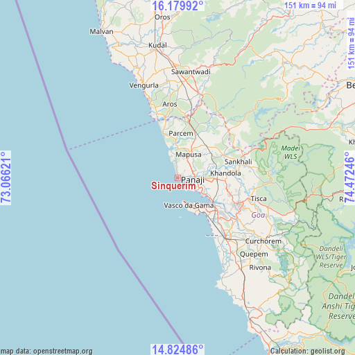
| Upper-left | 16.17992°, | 73.06621° |
| Center: | 15.5035°, | 73.76933° |
| Lower-right: | 14.82486°, | 74.47246° |
| Map W x H: | 150.7×150.7 km | = 93.6×93.6mi |
| max Lat: | 34.9274° ⇑79.7% North |
| Sinquerim: | 15.5035° |
| min Lat: | ⇓20.3% South 8.09008° |
| min Long | Sinquerim | max Long |
| 68.82655° | 73.76933° | 96.81° |
| W 8.6%⇐ | ⇒91.4% E |
Elevation
Elevation of Sinquerim is 15 m = 49 ft, and this is 280.6 m = 921 ft below average elevation for this country.
| Max E: |
3681 m = 12077 ft | 91.9% |
| Avg. | 295.6 m = 970 ft | |
| Sinquerim | 15 m = 49 ft | |
Min E: |
1 m = 3 ft | 8.1% |
See also: India elevation on elevation.city.
Geographical zone
Sinquerim is located in North Torrid zone (between Equator and Tropic of Cancer). Distance of this Northern Tropic circle is 882.1 km =548.1 mi to North.| Distance of | km | miles | from Sinquerim |
|---|---|---|---|
| North Pole | 8283.2 | 5146.9 | to North |
| Arctic Circle | 5677.3 | 3527.7 | to North |
| Tropic Cancer | 882.1 | 548.1 | to North |
| Equator | 1723.8 | 1071.1 | to South |


Nearby cities:
15 places around Sinquerim: (largest is in red/bold)
• Baga
7 km =4.3 mi,  347°
347°
• Bambolim
10 km =6.2 mi,  116°
116°
• Calangute
4.7 km =2.9 mi,  341°
341°
• Candolim
1.8 km =1.1 mi, 335°
• Chapora
11.5 km =7.1 mi, 344°
• Guirim
9 km =5.6 mi,  26°
26°
• Mormugao
13.6 km =8.5 mi,  158°
158°
• Māpuca
10.7 km =6.6 mi,  23°
23°
• Panaji
6.2 km =3.9 mi,  98°
98°
• Saligao
6 km =3.7 mi, 22°
• Serula
9.3 km =5.8 mi,  58°
58°
• Solim
12.4 km =7.7 mi,  359°
359°
• Taleigao
7.8 km =4.8 mi, 119°
• Vagator
10.8 km =6.7 mi, 345°
• Vasco da Gama
13 km =8.1 mi, 157°
Sources, notices
• [Note1] Compared only with cities in India existing in our database
• [Src1] Map data: © OpenStreetMap contributors (CC-BY-SA)
• [Src2] Other city data from geonames.org with taken over terms of usage.
• [Src3] Geographical zone / Annual Mean Temperature by Robert A. Rohde @ Wikipedia
